GIS-Driven Biomass Transport Route Optimization: Enhancing Efficiency and Sustainability in Biomass Supply Chains
This article explores the application of Geographic Information Systems (GIS) for optimizing biomass transport routes, a critical challenge in sustainable bioenergy and bioproduct supply chains.
GIS-Driven Biomass Transport Route Optimization: Enhancing Efficiency and Sustainability in Biomass Supply Chains
Abstract
This article explores the application of Geographic Information Systems (GIS) for optimizing biomass transport routes, a critical challenge in sustainable bioenergy and bioproduct supply chains. Targeting researchers, scientists, and drug development professionals, it provides a comprehensive overview from foundational concepts to advanced methodologies. The content covers the core challenges of biomass logistics, detailed GIS-based modeling techniques (including network analysis and multi-criteria decision-making), strategies for troubleshooting and enhancing model performance, and rigorous validation frameworks. The synthesis offers actionable insights for reducing costs, minimizing environmental impact, and improving the reliability of biomass feedstock delivery for industrial and research applications, including bio-based pharmaceutical precursors.
Understanding the Biomass Logistics Challenge: Why GIS is a Game-Changer
Within the scope of a GIS-based biomass transport route optimization research thesis, defining the operational framework is paramount. This document outlines the core objectives and constraints that govern the optimization model, serving as the foundational application notes for subsequent spatial analysis and algorithmic development. The protocols are designed for researchers and professionals requiring reproducible methodologies for supply chain cost minimization and efficiency analysis.
Key Optimization Objectives
The primary objectives are quantifiable metrics to be minimized or maximized by the routing algorithm.
Table 1: Primary Optimization Objectives
| Objective | Metric | Description | Typical Unit |
|---|---|---|---|
| Minimize Total Cost | Monetary Sum | Sum of fixed (vehicle) and variable (fuel, labor, maintenance) costs. | $ (USD/EUR) |
| Minimize Transportation Distance | Geodesic/Network Distance | Total travel distance from feedstock origins to biorefinery. | km or miles |
| Minimize Energy Consumption | Fuel Usage | Direct function of distance, vehicle load, and road gradient. | liters (l), GJ |
| Minimize Environmental Impact | CO₂-equivalent Emissions | Calculated from fuel consumption and emission factors. | kg CO₂-eq |
| Maximize Resource Utilization | Vehicle Load Factor | Ratio of actual payload to maximum vehicle capacity. | % |
System Constraints
Constraints are immutable boundaries within which the optimization must operate.
Table 2: System Constraints in Biomass Transport
| Constraint Category | Specific Constraint | Description & Parameter |
|---|---|---|
| Supply | Biomass Availability | Seasonal, geographic yield (e.g., 500 dry tons/km²). |
| Demand | Biorefinery Capacity | Maximum intake (e.g., 1000 tons/day). |
| Vehicle | Payload Capacity | Maximum legal or physical load (e.g., 28 tons). |
| Network | Road Class Limitations | Restrictions on heavy goods vehicles for certain road types. |
| Temporal | Operational Time Window | Legal driving hours, facility receiving hours. |
| Spatial | Route Feasibility | GIS-derived: bridge weight limits, turning radii. |
Experimental Protocol: GIS-Based Route Cost Calculation
This protocol details the steps to calculate the cost variable for a given route set.
Title: GIS Protocol for Per-Route Transport Cost Modeling
Workflow Diagram Title: Biomass Route Cost Calculation Workflow
Procedure:
- Input: A candidate route (shapefile/KML) from depot to biorefinery.
- Distance Calculation: Use GIS Network Analyst to compute actual road distance (km).
- Attribute Attachment: Spatially join road network attributes (speed limit, elevation profile) to the route.
- Time Estimation: Divide distance by average speed (adjusted for road class). Sum for total route time (h).
- Fuel Consumption Model: Apply formula:
- Fuel (l) = Distance * [Base Rate (l/km) + Load Factor * Gradient Penalty (l/km/%grade)].
- Base Rate and Penalty from vehicle specification sheets.
- Cost Calculation:
- Fuel Cost = Fuel (l) * Fuel Price ($/l).
- Labor Cost = Time (h) * Driver Wage ($/h).
- Maintenance Cost = Distance (km) * Maintenance Rate ($/km).
- Total Route Cost = Sum of above costs.
The Scientist's Toolkit: Research Reagent Solutions
Table 3: Essential Materials & Software for GIS-Based Biomass Transport Research
| Item / Solution | Function in Research | Example / Specification |
|---|---|---|
| Geographic Information System (GIS) | Spatial data integration, network analysis, and visualization. | ArcGIS Pro, QGIS (Open Source). |
| Road Network Dataset | Provides the graph for routing. Includes class, speed, restrictions. | OpenStreetMap, HERE Technologies, official national data. |
| Digital Elevation Model (DEM) | Provides terrain data for gradient calculation. | SRTM (30m), LiDAR-derived DEM (1m). |
| Vehicle Routing Problem (VRP) Solver | Algorithmic engine for optimization. | Google OR-Tools, HeuristicLab, custom Python (PyGAD). |
| Biomass Yield Raster Data | Spatially explicit supply quantification. | Remote sensing derived (NDVI), agricultural census data. |
| Fuel Consumption Model Coefficients | Converts route parameters to energy use. | Published factors from EPA or specific truck manufacturer data. |
Protocol: Constraint Integration in Optimization Model
This protocol describes how to hard-code constraints into a VRP solver.
Title: Protocol for Embedding Constraints in VRP Solver
Diagram Title: VRP Constraint Integration Logic
Procedure:
- Solver Initialization: Define the VRP with locations (depots, fields, biorefinery) using the solver's API (e.g., OR-Tools).
- Add Distance Matrix: Populate a matrix of travel costs between all points using outputs from Protocol 3.
- Define Dimension for Capacity:
- Create a "capacity" dimension.
- At each field node, add a demand equal to the biomass volume.
- Set the vehicle capacity equal to the truck payload constraint (Table 2).
- Define Dimension for Time:
- Create a "time" dimension using travel time + fixed unloading time.
- Set allowed time windows for the biorefinery node.
- Add Destination Constraint: Program the solver to ensure all routes terminate at the biorefinery node.
- Solve: Execute the solver (e.g., using a First Solution Heuristic like "Path Cheapest Arc" followed by a metaheuristic like "Guided Local Search").
- Feasibility Check: The solver will only return solutions that do not violate the hard-coded constraints.
Application Notes: GIS-Based Biomass Transport Optimization in Biopharma
Contextual Rationale
For researchers and drug development professionals, the procurement of specialized biomass (e.g., plant-derived APIs, algal bioreactor feedstocks, transgenic plant material) is fraught with logistical challenges. Geographic Information Systems (GIS) provide a critical framework for optimizing these supply chains, directly impacting research budgets, sustainability goals, and resilience against volatility.
The following tables consolidate key variables for modeling biomass transport for research-scale biopharma applications.
Table 1: Cost Drivers in Biomass Transport Logistics
| Cost Component | Typical Range (per ton-km) | Key Influencing Factors | Impact on Research Budget |
|---|---|---|---|
| Freight Charges | $0.18 - $0.35 | Fuel price, route accessibility, load factor | High; direct variable cost |
| Pre-processing (Field-side) | $15 - $45/ton | Moisture content, contamination control, initial stabilization | Critical for preserving bioactivity |
| Cold Chain Logistics | 40-70% premium over dry | Temperature control, monitoring equipment, energy use | Very High for sensitive feedstocks |
| Regulatory & Compliance | Fixed $500-$2000/shipment | Phytosanitary certs, GMO transport permits, material transfer agreements | Administrative overhead, risk of delay |
Table 2: Carbon Footprint Coefficients for Transport Modes
| Transport Mode | Avg. CO₂e (kg/ton-km) | Typical Use Case in Biomass Supply | Notes for Sustainability Reporting |
|---|---|---|---|
| Light Commercial Truck | 0.25 - 0.35 | Short-haul from farm to primary processing lab | Dominant for last-mile; electrification potential |
| Heavy-Duty Truck (Refrigerated) | 0.15 - 0.20 | Regional transport of stabilized biomass | High absolute emissions; optimization priority |
| Rail | 0.02 - 0.04 | Long-haul for bulk, non-perishable feedstocks | Lowest footprint but limited network access |
| Maritime (Short Sea) | 0.01 - 0.03 | International sourcing of marine/algal biomass | Efficient but adds significant lead time |
Table 3: Volatility Risk Index for Common Biomass Types
| Biomass Type | Cost Volatility (Annual Δ%) | Supply Disruption Risk | Key Volatility Drivers |
|---|---|---|---|
| Transgenic Plant Tissue (e.g., Tobacco) | 15-25% | Medium-High | Regulatory shifts, containment failures, seasonal yield |
| Marine Macroalgae | 20-40% | High | Storm events, water quality, harvesting licenses |
| Fermentation Feedstock (e.g., Corn Stover) | 10-30% | Medium | Commodity crop prices, agricultural policy |
| Specialized Medicinal Plant | 30-60% | Very High | Climate sensitivity, single-source geography, pest outbreaks |
Experimental Protocols for GIS Route Optimization
Protocol: Multi-Criteria GIS Network Analysis for Optimal Route Generation
Objective: To determine the least-cost, lowest-emission, and most resilient transport route between biomass source and research facility.
Materials & Software:
- GIS Software (QGIS 3.34 or ArcGIS Pro 3.2)
- Road Network Data (OpenStreetMap or national shapefile)
- Biomass source and destination point data (Lat/Long)
- Fuel price index data
- Vehicle emission factors database (e.g., EPA MOVES model coefficients)
- Historical traffic/closure data (where available)
Methodology:
- Network Preparation:
- Load road network layer. Assign impedance (cost) attributes to each road segment:
Length (km),Average Speed (km/h),Road Type (Highway, Primary, Secondary),Toll (Y/N). - Create additional impedance columns via Field Calculator:
Time_Cost = (Length / Avg_Speed) * Hourly_Driver_RateFuel_Cost = Length * (Fuel_Price / Vehicle_Fuel_Efficiency)Carbon_Cost = Length * Vehicle_Emission_Factor * Social_Cost_of_Carbon
- Load road network layer. Assign impedance (cost) attributes to each road segment:
- Multi-Criteria Cost Function:
- Define a weighted total cost function for each road segment (i):
Total_Cost_i = (α * Fuel_Cost_i) + (β * Time_Cost_i) + (γ * Carbon_Cost_i)- Weights (α, β, γ) are determined via stakeholder analysis (e.g., α=0.5 for budget focus, γ=0.3 for sustainability focus).
- Define a weighted total cost function for each road segment (i):
- Route Solving:
- Use the Network Analyst tool (Shortest Path function).
- Set the impedance to the calculated
Total_Costfield. - Input source and destination points. Execute solver to generate the optimal route (Path A).
- Resilience Analysis (k-shortest paths):
- Re-run the solver to identify the 2nd and 3rd best routes (Paths B, C) by cost.
- Compare these alternatives. A route with <10% higher cost but that uses a fundamentally different road network (e.g., avoids a single critical bridge) is a high-value resilient alternative.
- Volatility Stress Test:
- Adjust key inputs (e.g., increase
Fuel_Priceby 30%, setAvg_Speedto zero for a random 5% of primary roads to simulate disruption). - Re-run the model. Document how the optimal path shifts and the percentage increase in total cost.
- Adjust key inputs (e.g., increase
Protocol: Life Cycle Assessment (LCA) Integration for Carbon Footprint Validation
Objective: To empirically validate the GIS-modeled carbon footprint of a selected biomass transport route.
Materials:
- Vehicle telematics data logger (e.g., Geotab GO device)
- On-board diagnostics (OBD-II) port connector
- Fuel consumption records (or electric vehicle kWh usage)
- LCA software (OpenLCA 2.0 or SimaPro)
- Ecoinvent 3.8+ database
Methodology:
- Primary Data Collection:
- Install telematics logger on biomass transport vehicle.
- For the route determined in Protocol 2.1, record:
GPS track,instantaneous fuel consumption (L/km),engine load (%),idling time. - Perform 3-5 replicate runs to account for traffic variability.
- System Boundary Definition:
- Set LCA system boundary from "Well-to-Wheel": include fuel/electricity production and vehicle operation. Exclude vehicle manufacturing.
- Inventory Modeling in LCA Software:
- Create a process for "Biomass Transport - [Route Name]".
- Input the average fuel consumption per km from primary data.
- Link fuel input to the background dataset "Diesel, burned in diesel-electric generating set {GLO}| market for | Cut-off, U".
- For electric vehicles, link kWh input to the appropriate regional electricity market dataset.
- Impact Assessment:
- Calculate using the IPCC 2021 GWP 100y method.
- The output (
kg CO₂e / ton-km) is the validated footprint. Compare this result to the GIS-modeled coefficient from Table 2. Discrepancy >15% requires GIS model parameter recalibration.
Visualizations
GIS-Based Biomass Route Optimization Workflow
Multi-Stakeholder Decision Model for Routing
The Scientist's Toolkit: Research Reagent Solutions for Biomass Logistics Analysis
| Item / Reagent | Function in GIS-Based Transport Research | Example Product / Source |
|---|---|---|
| GIS Software with Network Analyst | Core platform for spatial data management, network modeling, and least-cost path analysis. | ArcGIS Pro (Esri), QGIS with GRASS & PyQGIS |
| Vehicle Telematics Logger | Captures empirical fuel consumption, route adherence, and idle time for model validation. | Geotab GO Series, Veepeak OBDCheck BLE+ |
| Life Cycle Inventory (LCI) Database | Provides validated emission factors for fuel production, electricity, and vehicle operations. | Ecoinvent Database, USLCI (NREL) |
| Social Cost of Carbon (SCC) Value | A monetary metric ($/ton CO₂e) used to internalize climate impact into the economic cost function. | EPA Current SCC Estimates (2025+) |
| Geospatial Road Network Data | The foundational vector dataset containing routable links (roads) with attributes (type, speed). | OpenStreetMap (OSM), HERE Technologies, TomTom |
| Programming Interface (API) | Enables automation of repetitive analyses (e.g., daily route re-optimization) and data fetching. | Google Routes API, OSRM, OR-Tools (Google) |
| Climate Risk Data Layers | Raster or vector data projecting flood, fire, or drought risk to assess route vulnerability. | IPCC AR6 Atlas, WorldClim, NOAA Climate.gov |
Core Spatial Analysis Capabilities for Logistics
Geographic Information Systems (GIS) provide foundational analytical capabilities for optimizing logistics networks, particularly within the context of biomass transport for drug development feedstocks. The table below summarizes the quantitative performance metrics of key GIS spatial analysis functions relevant to logistics optimization.
Table 1: Core GIS Analytical Functions and Their Logistics Applications
| GIS Capability | Key Metric/Output | Typical Performance Range/Value | Primary Application in Biomass Logistics |
|---|---|---|---|
| Network Analysis (Route Optimization) | Computational Time for 1000-node network | 2-15 seconds (varies by algorithm) | Calculating least-cost paths for biomass collection from diffuse sources to biorefineries. |
| Cost-Distance Analysis | Raster resolution for accurate modeling | 10m - 30m cell size | Modeling travel impedance based on slope, road type, and legal constraints for transport vehicles. |
| Spatial Interpolation (Kriging) | Root Mean Square Error (RMSE) | 5-15% of data range | Estimating biomass yield or quality metrics across a catchment area from point sample data. |
| Service Area/Demand Allocation | Facility reach (time/distance) | Isochrones of 30, 60, 90 minutes | Defining optimal catchment zones for biomass collection hubs to minimize total transport distance. |
| Suitability Modeling (Weighted Overlay) | Model accuracy (AUC score) | 0.7 - 0.9 (Area Under Curve) | Identifying optimal locations for intermediate storage or preprocessing facilities. |
Application Notes: GIS in Biomass Transport Route Optimization
For a thesis focused on GIS-based biomass transport optimization, the application moves beyond simple shortest-path calculation. The core objective is to minimize the total system cost (economic, energetic, and environmental) for moving heterogeneous biomass from harvest sites to a central processing facility for drug development precursors.
Key Considerations:
- Variable Feedstock Density: Biomass energy density (MJ/ton) and bulk density (kg/m³) vary significantly by source (e.g., agricultural residue, energy crops, forestry waste). This impacts vehicle payload and required trip frequency.
- Temporal Constraints: Harvest windows and biomass degradation rates impose time-bound routing solutions, requiring spatiotemporal analysis.
- Infrastructure Limitations: Bridge weight limits, seasonal road accessibility, and proximity to suitable loading/unloading sites must be integrated as network constraints.
- Multi-Objective Optimization: The optimal route must balance cost, carbon footprint, and road safety (e.g., avoiding residential areas with heavy traffic).
Table 2: Key Biomass-Specific Parameters for GIS Logistics Modeling
| Parameter Category | Specific Variable | Typical Data Source | Impact on Routing |
|---|---|---|---|
| Biophysical | Yield (tons/ha) | Remote sensing (NDVI), agricultural surveys | Determines the spatial density of supply and collection point locations. |
| Economic | Haulage Cost ($/ton/km) | Logistics industry benchmarks, fuel price indices | Primary variable for least-cost path analysis. Often varies by road class. |
| Environmental | Soil Moisture / Bearing Capacity | Soil maps, weather station data | Determines off-road accessibility for collection equipment; prevents soil compaction. |
| Regulatory | Road Weight Restrictions | Department of Transportation datasets | Eliminates road segments from the network for heavy transport vehicles. |
| Temporal | Harvest Season Duration | Phenological models, farmer interviews | Defines the analysis period and required transport capacity. |
Experimental Protocols for GIS-Based Route Optimization
Protocol 3.1: Network Dataset Creation and Impedance Modeling
Objective: To construct a routable network model that accurately reflects real-world travel impedance for biomass transport vehicles.
Materials & Software: Esri ArcGIS Pro or QGIS with Network Analyst extension; OpenStreetMap or national road network vector data; national bridge inventory; digital elevation model (DEM).
Methodology:
- Data Acquisition & Cleaning:
- Download road network data (e.g., LINESTRINGs). Retain essential attributes: road class, name, speed limit, pavement type.
- Merge with bridge inventory data. Assign a
Max_Weight_Tonsattribute based on regulatory ratings.
- Network Topology Creation:
- Build a network dataset. Ensure all lines connect at intersections (snap tolerance: 5 meters).
- Define connectivity policies (e.g., endpoints connect, any vertex can connect).
- Impedance (Cost) Attribute Calculation:
- Create a
TravelTimeattribute. Calculate using:(Shape_Length / (Speed_Limit * 0.44704)) * 1.2. The 1.2 factor accounts for delays. - Create a
HaulageCostattribute. For each road segment:(Shape_Length / 1000) * Fuel_Consumption_L_per_km * Fuel_Price_per_L. - Create a
VehicleConstraintattribute. Apply restrictions for road classes unsuitable for heavy goods vehicles (HGVs).
- Create a
- Validation:
- Conduct test routes between known points. Compare GIS-calculated travel times against real-world GPS tracklog data (e.g., from 10 sample runs). Calibrate impedance factors until mean absolute percentage error (MAPE) is <15%.
Protocol 3.2: Multi-Criteria Least-Cost Path Analysis for Biomass Transport
Objective: To determine the optimal route between a biomass source and a biorefinery, minimizing a weighted combination of cost, time, and environmental impact.
Materials & Software: Raster-based GIS (e.g., ArcGIS Spatial Analyst); Friction surface rasters; Origin and destination point data.
Methodology:
- Friction Surface Development:
- Convert the road network's
HaulageCostattribute to a raster (10m resolution). This is the base cost layer (C_cost). - Create an environmental impact raster (
C_env). Assign high cost values to segments near sensitive habitats (from land cover maps) or through densely populated areas (from census data). - Create a safety raster (
C_safe). Assign higher costs to road segments with sharp curvatures (derived from DEM) or high historical accident rates.
- Convert the road network's
- Weighted Cost Integration:
- Assign researcher-determined weights (w1, w2, w3) to each cost layer, where w1 + w2 + w3 = 1. (e.g., Economic: 0.5, Environmental: 0.3, Safety: 0.2).
- Use the Raster Calculator to create a composite friction surface:
C_total = (w1 * C_cost) + (w2 * C_env) + (w3 * C_safe).
- Least-Cost Path Calculation:
- Execute the Cost Distance tool using the biorefinery as the destination source. This calculates the accumulated cost to reach every cell from the destination.
- Execute the Cost Path tool for each biomass source point, using the accumulated cost raster. This generates the optimal path for each origin.
- Sensitivity Analysis:
- Re-run the analysis (Steps 2-3) with varying weight combinations (e.g., prioritizing environment over cost).
- Compare the total system cost (summed length * cost for all routes) and spatial alignment of routes under each scenario.
Visualization: GIS Logistics Optimization Workflow
Diagram Title: GIS Workflow for Biomass Transport Optimization
The Scientist's Toolkit: Research Reagent Solutions
Table 3: Essential GIS Data & Analytical "Reagents" for Biomass Logistics Research
| Item Name / Category | Source / Example | Primary Function in Research |
|---|---|---|
| Base Network Vector Data | OpenStreetMap, HERE Technologies, National Transport Authority Datasets | Provides the fundamental routable graph (edges and nodes) representing the transport infrastructure. |
| Digital Elevation Model (DEM) | SRTM (30m), LiDAR-derived (1-3m), Copernicus DEM | Enables slope calculation for impedance modeling and identifies terrain obstacles for off-road transport feasibility. |
| Land Use/Land Cover (LULC) Raster | CORINE Land Cover, USGS NLCD, ESA WorldCover | Identifies environmentally sensitive areas for avoidance and locates potential biomass sources (e.g., agricultural fields, forests). |
| Multi-Spectral Satellite Imagery | Sentinel-2, Landsat 8/9 | Used to calculate vegetation indices (NDVI) for estimating biomass yield and monitoring harvest timing (phenology). |
| Network Analysis Engine | Esri Network Analyst, pgRouting (PostGIS), OpenRouteService API | The computational core that executes routing algorithms (e.g., Dijkstra's, A*) on the prepared network dataset. |
| Geoprocessing Scripting Framework | Python (ArcPy, GeoPandas, PyQGIS), R (sf, igraph packages) | Automates repetitive analysis workflows (e.g., batch route calculation), ensures reproducibility, and handles sensitivity analyses. |
| Vehicle Specification Profile | Industry databases (e.g., for Volvo, Scania), Field measurements | Defines key parameters for the routing model: max payload (tons), fuel economy (L/km), axle weight, and turning radius. |
Types of Biomass Feedstocks and Their Unique Transport Requirements
This document provides detailed application notes and protocols for characterizing biomass feedstocks and their transport logistics, framed within a broader thesis on GIS-based biomass transport route optimization. The research aims to develop a spatial decision-support system that models the cost, energy, and emissions of biomass supply chains from diverse feedstocks to centralized bioprocessing facilities for drug development and bioproduct synthesis.
Biomass Feedstock Classification and Properties
Biomass feedstocks are categorized based on origin, physicochemical properties, and their implications for handling, storage, and transport.
Table 1: Classification and Key Properties of Major Biomass Feedstocks
| Feedstock Category | Examples | Bulk Density (kg/m³) | Moisture Content (% wet basis) | Specific Energy (GJ/tonne, dry) | Flowability | Perishability / Degradation Risk |
|---|---|---|---|---|---|---|
| Herbaceous Crops | Miscanthus, Switchgrass, Corn Stover | 80-150 (loose) | 15-20 (baled) | 17-19 | Low (loose), Moderate (baled) | Moderate (biological, moisture) |
| Agricultural Residues | Straw, Husks, Bagasse | 50-100 (loose) | 10-25 | 15-18 | Very Low (loose) | High (microbial, seasonal) |
| Woody Biomass | Forest Logging Residues, Short-Rotation Coppice | 200-300 (chipped) | 30-50 (green) | 18-20 | Moderate (chipped) | Low (if dried) |
| Energy Crops | Willow, Poplar (SRC) | 250-350 (chipped) | 40-60 (green) | 19-20 | Moderate | Low |
| Organic Wastes | Food Waste, Manure, MSW* | 300-600 | 40-80 | 8-15 | Variable, Often Low | Very High (biological, odor) |
| Aquatic Biomass | Algae (micro, macro), Duckweed | 50-100 (dewatered cake) | 70-90 (harvested slurry) | 10-25 | Very Low (slurry) | Very High (rapid spoilage) |
*MSW: Municipal Solid Waste (biogenic fraction).
Transport Requirement Protocols and GIS Integration
The following protocols outline methods to quantify transport-related parameters for GIS modeling.
Protocol 3.1: Field-Based Measurement of Biomass Bulk Density and Load Stability
Objective: To determine real-world bulk density and load characteristics for configuring GIS transport cost models. Materials:
- Standard ISO container or defined truck bed volume (V)
- Load cell or weighbridge
- Moisture meter
- Tarpaulin and securing straps
- Digital camera Procedure:
- Pre-weigh: Record tare weight (W_tare) of the empty transport unit.
- Loading: Load feedstock using standard field equipment (e.g., baler, chipper, conveyor). Avoid manual compaction unless typical.
- Post-weigh: Weigh loaded unit (Wgross) and calculate net biomass weight (Wnet = Wgross - Wtare).
- Volume Occupancy: Photographically document and estimate the proportion (P) of the nominal volume (V) occupied by biomass. Calculate effective volume (V_eff = V * P).
- Bulk Density Calculation: Calculate field bulk density (ρfield) as ρfield = Wnet / Veff.
- Moisture Sampling: Take ≥3 representative samples, determine average moisture content (MC).
- Dry Mass Basis: Recalculate load on a dry mass basis for energy content modeling: Wdry = Wnet * (1 - MC).
- GIS Attribute Assignment: Attribute ρfield, MC, and Wdry to the source polygon in the GIS layer for the sampled feedstock lot.
Protocol 3.2: Laboratory Determination of Biomass Degradation Kinetics for Transport Time Constraints
Objective: To model perishability and establish maximum allowable transport and storage duration. Materials:
- Anaerobic chamber or sealed containers
- Gas chromatograph (GC) or respirometer
- Temperature-controlled incubators
- Moisture-proof sample bags
- Biomass samples (fresh) Procedure:
- Sample Preparation: Prepare triplicate samples (≈500g each) at typical transport moisture content.
- Storage Simulation: Store samples in sealed containers under isothermal conditions (e.g., 5°C, 25°C, 40°C) simulating seasonal transport environments.
- Monitoring: At defined intervals (0, 12, 24, 48, 96, 168 hrs), measure:
- Headspace gases (CH₄, CO₂ via GC) as indicators of anaerobic digestion.
- Dry matter loss (via oven drying at 105°C).
- Visible mold growth (photographic index).
- Kinetic Modeling: Fit first-order decay models to dry matter loss data:
DM(t) = DM₀ * e^(-k*t), wherekis the temperature-dependent degradation rate constant. - GIS Integration: The rate constant
kinforms the temporal decay attribute in the network analysis. The maximum allowable transport time (t_max) for a permissible loss (e.g., 5%) is calculated ast_max = -ln(0.95)/k. Thist_maxbecomes a time-constraint in the GIS route optimization.
Protocol 3.3: GIS-Based Multi-Criteria Route Optimization for Diverse Feedstocks
Objective: To implement a GIS workflow that selects optimal transport routes balancing cost, time, and feedstock-specific constraints. Materials:
- GIS Software (e.g., ArcGIS Pro, QGIS with Network Analyst)
- Road network dataset (with attributes: road class, speed limit, tolls)
- Feedstock source points (with attributes: type, volume, ρ_field,
t_max, seasonality) - Processing facility location(s)
- Climate data (ambient temperature layers) Procedure:
- Network Impedance Modeling:
- Calculate base travel time for each road segment:
Time = Length / Speed. - For moisture-sensitive feedstocks (e.g., herbaceous), apply a weather-dependent speed reduction factor for roads exposed to precipitation (from real-time or historical data layers).
- Calculate base travel time for each road segment:
- Feedstock-Specific Cost Functions:
- Define variable cost ($/km) as a function of
ρ_field: Lower density incurs higher cost per unit energy transported. Use:Cost_km = a + b/ρ_field, whereaandbare calibrated constants. - Add fixed costs for specialized equipment (e.g., refrigerated trucks for waste, walking floor trailers for residues).
- Define variable cost ($/km) as a function of
- Constraint Application:
- Apply
t_maxfrom Protocol 3.2 as a network impedance ceiling. Any route with total time >t_maxis excluded. - For high-degradation risk feedstocks (e.g., wastes), model only facilities within the
t_maxisochrone.
- Apply
- Route Solving:
- Run a Closest Facility analysis minimizing
(Cost * Time). - Perform a sensitivity analysis by varying input parameters (e.g., fuel price, moisture content).
- Run a Closest Facility analysis minimizing
- Output: Optimal routes, associated costs, greenhouse gas emission estimates (based on fuel use model), and maps visualizing feedstock-specific supply corridors.
Visualizations
Diagram Title: Biomass Transport GIS Optimization Workflow
Diagram Title: Biomass Degradation Pathways During Transport
The Scientist's Toolkit: Research Reagent Solutions
Table 2: Essential Materials for Biomass Transport Logistics Research
| Item | Function in Research |
|---|---|
| Portable Moisture Meter | Rapid in-situ determination of feedstock moisture content for accurate density and degradation modeling. |
| Load Cell/Weighbridge System | Precisely measures biomass wet weight for calculating field bulk density and load efficiency. |
| Gas Chromatograph (GC) with TCD/FID | Quantifies CO₂ and CH₄ produced during biomass degradation experiments to establish kinetic rates. |
| Temperature/Humidity Data Loggers | Monitors environmental conditions during simulated transport or field trials for correlation with degradation. |
| GIS Software with Network Analyst Extension | The core platform for building spatial models, integrating feedstock attributes, and solving routing problems. |
| Unmanned Aerial Vehicle (UAV / Drone) | Captures high-resolution imagery of feedstock stockpiles for volume estimation and monitoring degradation. |
| Calibrated Sample Containers (ISO size) | Standardizes volume measurements for bulk density calculations across different research teams. |
| Respirometer | An alternative to GC for measuring microbial activity and oxygen consumption rates in biomass samples. |
Current Pain Points in Biomass Supply Chains for Research and Industry
Within the context of GIS-based biomass transport route optimization research, the supply chain for research and industrial biomass (e.g., medicinal plants, engineered crops, algal feedstocks) is fragmented. Key pain points directly impact the reproducibility of scientific experiments and the scalability of bio-based drug development. The following table quantifies major logistical and qualitative bottlenecks.
Table 1: Quantified Pain Points in Biomass Research Supply Chains
| Pain Point Category | Key Metric/Issue | Typical Impact on Research/Industry |
|---|---|---|
| Spatio-Temporal Variability | Biomass composition can vary >30% (e.g., metabolite concentration) based on harvest season and location. | Compromises experimental reproducibility; requires larger sample sizes for statistical power. |
| Post-Harvest Degradation | Loss of bioactive compounds can exceed 20% within 48 hours without controlled logistics. | Reduces yield of target molecules; introduces unknown variables in kinetic studies. |
| Fragmented Supplier Data | <50% of suppliers provide GIS-referenced (latitude/longitude) and standardized phytochemical profiles. | Hinders GIS modeling for optimal collection routes and supplier selection. |
| High Transport Cost & Complexity | Transport of temperature-sensitive biomass can account for 35-60% of total raw material cost. | Limits sourcing radius; makes rare or endemic species prohibitively expensive for high-throughput screening. |
| Lack of Standardized Protocols | Inconsistent pre-processing (drying, milling) methods among suppliers lead to high batch-to-batch variability. | Requires extensive re-validation of extraction protocols; delays project timelines. |
Application Notes & Experimental Protocols
AN-01: Protocol for Assessing Supplier-GIS Data Completeness
Purpose: To quantitatively evaluate and score biomass suppliers based on data critical for GIS transport modeling. Materials: Supplier specification sheets, GIS software (e.g., QGIS), data validation checklist.
Procedure:
- Data Collection: Compile all available data from the supplier for the last 10 biomass batches.
- Data Categorization: Classify data points into mandatory (M) and optional (O) for GIS modeling.
- M1: Precise geographic coordinates (lat/long) of harvest origin.
- M2: Harvest date and time.
- M3: Post-harvest handling method (e.g., "flash-frozen at -80°C within 2h").
- O1: Soil type data.
- O2: Local meteorological data at harvest.
- Scoring: Assign a score: 1 point for each complete M field per batch, 0.5 points for each O field. Calculate a percentage completeness score across all batches.
- GIS Integration: Plot supplier locations and score them on a GIS layer. Use this layer as a "Data Reliability" filter in route optimization models.
AN-02: Protocol for Monitoring Biomass Degradation During Simulated Transport
Purpose: To model the degradation kinetics of a target bioactive compound (e.g., artemisinin, paclitaxel precursor) under varying transport conditions.
Table 2: Research Reagent Solutions for Stability Testing
| Reagent/Material | Function in Protocol | Key Consideration |
|---|---|---|
| Lyophilized Biomass Standard | Provides a stable baseline control for analytical comparison. | Must be certified for target compound concentration. |
| Portable Data Loggers | Records temperature & humidity inside transport containers in real-time. | Critical for correlating environmental conditions with degradation rates. |
| HPLC-MS System | Quantifies target and degradation product concentrations over time. | Method must be validated for the specific compound matrix. |
| Stability Chambers | Simulates precise transport environments (e.g., 25°C/60% RH, 40°C/75% RH). | Allows for accelerated stability testing. |
| Standardized Extraction Kit | Ensures consistent compound recovery from biomass samples at each time point. | Eliminates extraction variability as a confounding factor. |
Procedure:
- Sample Preparation: Homogenize a single batch of raw biomass. Divide into 100g aliquots.
- Conditioning: Place aliquots in stability chambers programmed to simulate different transport scenarios (Refrigerated: 4°C; Ambient: 25°C/60% RH; Stress: 40°C/75% RH).
- Sampling: Extract and analyze triplicate samples at T=0, 2, 4, 8, 24, and 48 hours.
- Kinetic Analysis: Plot concentration of the target compound against time for each condition. Fit data to a degradation kinetic model (e.g., zero-order, first-order).
- GIS Integration: Model the "Degradation Cost" for potential routes by integrating kinetic data with predicted transit times and historical temperature data from GIS.
Visualizations
Biomass Supply Chain with Critical Pain Points
Workflow: Integrating Stability Data into GIS Optimization
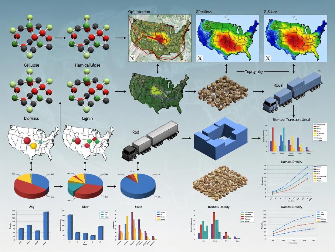
Building a GIS Route Optimization Model: A Step-by-Step Methodology
This document details the Application Notes and Protocols for acquiring the foundational geospatial datasets critical for GIS-based biomass transport route optimization research. Efficient route optimization for biomass feedstock logistics, a key cost component in biofuel and biochemical production, requires high-fidelity spatial data on transport corridors, topography, and supply chain nodes.
The optimization model requires three core vector/raster layers. The following table summarizes current (2024-2025) optimal sources, characteristics, and relevance to biomass transport.
Table 1: Critical Geospatial Data Layers for Biomass Transport Optimization
| Data Layer | Primary Use in Model | Recommended Current Sources | Key Quantitative Metrics & Specifications | Relevance to Biomass Research |
|---|---|---|---|---|
| Road Network | Defines traversable routes, calculates travel time/cost. | OpenStreetMap (OSM), HERE TomTom, USGS TIGER/Line. | Accuracy: >95% positional for primary roads. Attributes: Type, name, speed limit, weight/height restrictions. Update Frequency: OSM (real-time), Commercial (quarterly). | Identifies viable routes for heavy goods vehicles (HGVs); restrictions critical for high-volume biomass transport. |
| Terrain (DEM) | Calculates road grades, influences vehicle speed & fuel consumption. | NASADEM, Copernicus DEM (GLO-30), USGS 3DEP (1m-10m). | Resolution: 30m (NASADEM) to 1m (3DEP). Vertical Accuracy: ±2m (NASADEM) to ±0.1m (LiDAR-based). | Steep grades (>8%) significantly increase transport energy penalty; used for slope-derived impedance. |
| Facilities | Defines route origins (biomass depots) and destinations (biorefineries). | National/Regional Industry Directories, Permit Databases, Manual Digitization from Imagery. | Positional Accuracy: Required <10m for network snapping. Attributes: Type, capacity, operational status. | Precise location is mandatory for accurate distance calculation and logistics modeling between specific sites. |
Experimental Protocols for Data Acquisition & Preprocessing
Protocol 2.1: Acquisition and Topological Cleaning of Road Network Data Objective: To obtain a routable, topologically correct road network layer with relevant attributes for HGV routing. Methodology:
- Data Download: Access the OpenStreetMap (OSM) database via the Overpass API or Geofabrik download server. Use the query to extract all features with the key
highwaywithin the study area boundary. - Network Topology Construction: Use PostGIS (with pgRouting) or ArcGIS Network Analyst to construct a network dataset. Ensure all road segments are split at intersections (nodes).
- Attribute Enhancement:
- Assign a
speed_kmhattribute based on OSMhighwaytag (e.g., motorway=100, residential=30). - Assign a
biomass_impedancecost attribute. For segments tagged withmaxweightormaxheightbelow typical HGV thresholds (e.g., <40 tons), apply a multiplicative penalty factor (e.g., 5x) to discourage routing.
- Assign a
- Validation: Visually compare network connectivity against recent satellite basemaps (e.g., ESRI World Imagery) for missing links or errors.
Protocol 2.2: Deriving Road-Specific Slope from DEM for Energy Cost Modeling Objective: To calculate average slope per road segment for integration into the transport energy consumption model. Methodology:
- Data Alignment: Reproject the Digital Elevation Model (DEM) source (e.g., Copernicus GLO-30) to match the coordinate reference system (CRS) of the road network.
- Sample Elevation Points: Using QGIS or ArcPy, generate points at a consistent interval (e.g., every 20m) along each road segment.
- Extract Elevation Values: Use the
Sampletool to extract the elevation value from the DEM at each point location. - Calculate Segment Slope: For each road segment, process the sequence of point elevations. Compute the cumulative elevation gain and loss along the segment. Calculate the average slope (%) as
(Total Elevation Change / Segment Length) * 100. - Integrate with Network: Join the calculated
avg_slope_pctattribute to the corresponding road segment in the network dataset.
Mandatory Visualizations
Title: Biomass Transport GIS Data Pipeline
Title: Road Slope Extraction Workflow
The Scientist's Toolkit: Research Reagent Solutions
Table 2: Essential GIS Tools & Data for Biomass Route Analysis
| Item / Reagent Solution | Function in Research Protocol | Exemplary Tools / Sources |
|---|---|---|
| Network Analysis Engine | Performs shortest path, service area, and route optimization calculations on the attributed graph. | pgRouting (Open Source), ArcGIS Network Analyst, QGIS native algorithms. |
| Geospatial Processing Library | Automates data cleaning, transformation, and analysis (e.g., slope calculation protocol). | GDAL/OGR, Geopandas (Python), ArcPy (ArcGIS), R sf package. |
| High-Resolution DEM Source | Provides the terrain model for slope and grade analysis. | Copernicus DEM, USGS 3DEP LiDAR, NASA Ames Stereo Pipeline outputs. |
| Crowd-Sourced Vector Basemap | The primary source for routable road networks with global coverage. | OpenStreetMap (OSM) accessed via Overpass API or osm2pgsql. |
| Precision Facility Geocoder | Converts facility addresses or coordinates to precise network nodes. | Local gazetteers, manual digitization from satellite imagery, GPS data collection. |
| Transport Impedance Model | Defines the cost function (time, energy, USD) for network traversal. | Custom model integrating speed, grade, surface type, and vehicle-specific constants. |
Within the broader thesis on GIS-based biomass transport route optimization for biorefinery feedstock logistics, the creation of a high-fidelity network dataset is foundational. This dataset must model real-world transport impedances—factors that slow or hinder movement—to accurately simulate truck travel for biomass collection and delivery. This protocol details the acquisition, processing, and impedance attribution of spatial data critical for calculating realistic travel times and costs, a prerequisite for optimizing sustainable biofuel and bioproduct supply chains.
Research Reagent Solutions & Essential Materials
| Item Name | Function in Network Dataset Creation |
|---|---|
| OpenStreetMap (OSM) | A crowd-sourced, global vector basemap providing the fundamental road network geometry (lines) and attributes (type, name). |
| U.S. Census TIGER/Line | An authoritative source for road network data in the United States, often used to validate or supplement OSM data. |
| Digital Elevation Model (DEM) | A raster grid of ground elevation. Essential for calculating road grade, a key impedance for heavy trucks. |
| Traffic Data (e.g., HERE, TomTom) | Commercial or public historical average speed data by road segment and time of day. Critical for modeling congestion-based impedance. |
| Legal Vehicle Dimension/Weight Data | State and federal regulations defining maximum gross vehicle weight, axle weights, and permitted dimensions. Determines routing constraints. |
| GIS Software (e.g., QGIS, ArcGIS Pro) | Platform for spatial data integration, network construction, impedance field calculation, and topology validation. |
| Network Analysis Library (e.g., pgRouting, NetworkX) | Software library for performing shortest path and route optimization calculations on the attributed network graph. |
Core Experimental Protocol: Network Dataset Assembly & Impedance Modeling
Protocol 3.1: Base Network Extraction and Topology Cleaning
- Data Acquisition: Download road network data for your study region from OpenStreetMap using a tool like
osmnxor the OSM export portal. Alternatively, use Census TIGER/Line data. - Network Pruning: Filter the raw data to include only roads navigable by medium- and heavy-duty trucks (e.g., exclude pedestrian paths, private roads). Retain attributes:
road_type,maxspeed,name,length. - Topology Construction:
- Ensure all road segments (edges) connect at intersections (nodes). Split lines at all intersections.
- Remove duplicate geometries and dangles (false dead-ends).
- Assign unique IDs to all nodes and edges.
- Create a clean, directed graph
G(N, E)whereNis the set of nodes andEis the set of edges.
Protocol 3.2: Impedance Factor Calculation & Attribution
Impedance is modeled as traversal cost per edge, primarily as time (seconds). Calculate and add the following fields to each edge in the network table.
Base Travel Time (
t_base):avg_speed: Derived frommaxspeedtag (OSM) or functional class (TIGER). Override with historical traffic speed data (Protocol 3.3) where available.
Grade Impedance Factor (
f_grade): For heavy trucks, grade significantly impacts speed.- Extract elevation for each node from a DEM (e.g., USGS 3DEP).
- Calculate segment grade:
grade (%) = (Δelevation / length) * 100. - Apply a grade-speed reduction model. A simplified linear correction factor (based on Rakha et al., 2001):
Adjusted time:
t_grade = t_base * f_grade
Surface Impedance Factor (
f_surface): Unpaved roads increase rolling resistance and reduce safe speed.- Classify
road_typeas Paved or Unpaved. - Apply a conservative speed reduction (e.g., 25%) for unpaved segments.
Adjusted time:
t_surface = t_grade * f_surface
- Classify
Final Edge Cost (
cost_seconds):This composite cost is the primary impedance used in routing optimization.
Protocol 3.3: Integration of Dynamic Traffic Data (If Available)
- Data Matching: Acquire historical average speed profiles (e.g., by hour, day of week) from a provider like HERE Technologies.
- Spatial Join: Match speed profile segments to the cleaned network geometry using GIS tools.
- Temporal Cost Field: Create multiple
cost_secondsfields for different time slices (e.g.,cost_peak,cost_offpeak) using the time-specific average speeds instead of the staticavg_speedin Protocol 3.2, Step 1.
Protocol 4.4: Constraint Attribution for Vehicle Regulations
Add Boolean fields to edges to act as restrictions during routing.
weight_limit_ok:TRUEif edge's legal weight limit > configured truck GVW.height_limit_ok:TRUEif edge's clearance > truck height.truck_ok:TRUEif trucks are legally permitted on the road.
Table 1: Standard Impedance Correction Factors for Biomass Trucks
| Impedance Factor | Condition | Correction Formula | Applied To |
|---|---|---|---|
| Grade | Uphill (>0% grade) | f_grade = 1 + (0.04 * grade) |
t_base |
| Road Surface | Unpaved | f_surface = 1.25 |
t_grade |
| Congestion (Example) | Peak vs. Off-Peak | Use time-sliced avg_speed from traffic data |
Replaces base speed |
Table 2: Example Network Edge Attribute Table (Subset)
| edge_id | length_m | road_type | maxspeed_kmh | avgspeedkmh* | grade_pct | cost_seconds |
|---|---|---|---|---|---|---|
| 1001 | 1250 | secondary | 80 | 72 | 2.5 | 68.1 |
| 1002 | 850 | unclassified | 50 | 40 | 0.0 | 76.5 |
| 1003 | 500 | track | 30 | 20 | -1.0 | 112.5 |
Note: avg_speed may be reduced from maxspeed based on road class or traffic data.
Visualization of Workflows
Title: Impedance Network Creation Workflow
Title: Single Edge Cost Calculation Logic
Application Notes: Algorithm Integration in Biomass Transport Optimization
These notes detail the application of geospatial algorithms within a thesis focused on optimizing biomass feedstock transport for biofuel and pharmaceutical precursor production. Efficient routing directly impacts feedstock cost, quality preservation, and sustainability metrics critical for drug development supply chains.
Table 1: Core Geospatial Algorithms and Their Biomass Transport Application
| Algorithm Class | Primary Function | Biomass-Specific Application | Key Output Metrics |
|---|---|---|---|
| Shortest Path | Finds the minimum-cost path between two nodes on a network. | Calculating point-to-point transport distance/time for biomass from a known field to a single biorefinery. | Distance (km), Travel Time (min), Fuel Cost (USD). |
| Vehicle Routing Problem (VRP) | Determines optimal routes for a fleet of vehicles to service multiple locations. | Coordinating multiple harvest teams or trucks from a depot to numerous biomass collection points (fields) with capacity constraints. | Total Fleet Distance, Number of Vehicles Required, Route Sequence per Vehicle, Load Utilization (%). |
| Location-Allocation | Allocates demand points to supply facilities and/or selects optimal facility locations. | Siting biorefinery or preprocessing depot locations to minimize total transport cost from dispersed biomass sources. | Optimal Facility Locations, Assignment of Supply Zones, System-Wide Total Transport Cost. |
Table 2: Representative Quantitative Data from GIS-Based Biomass Routing Studies
| Study Focus | Algorithm(s) Used | Network Scale | Reported Efficiency Gain vs. Baseline | Key Constraint Modeled |
|---|---|---|---|---|
| Corn Stover Collection | VRP (Clarke-Wright) | 150 fields | 18.7% reduction in total route distance | Truck capacity, time windows |
| Forest Residue Transport | Location-Allocation (p-median) | 5 potential depot sites | 22.4% lower avg. haul distance | Depot throughput capacity |
| Herbaceous Biomass | Shortest Path (A*) & VRP | 3000 road segments | 15.2% fuel savings | Road class restrictions, load-dependent speed |
Experimental Protocols
Protocol: GIS-Based Multi-Depot VRP for Seasonal Biomass Harvest
Objective: To generate optimal daily harvest vehicle routes for multiple biomass depots under time and capacity constraints. Materials: Road network data, biomass field polygon layer (with yield attribute), depot location points, vehicle specifications (capacity, avg. speed). Software: QGIS with OR-Tools/VROOM plugin or ArcGIS Pro with Network Analyst.
Methodology:
- Network Preparation: Prepare a directed road network with impedance (travel time) attributes. Calculate a cost matrix between all biomass field centroids and depot locations.
- Parameterization: Define constraints:
- Vehicle capacity: 20 tons (wet weight).
- Maximum route duration: 8 hours.
- Field service time: 45 minutes (for loading).
- Algorithm Execution: Implement a Clarke-Wright Savings Algorithm or a Metaheuristic (e.g., Tabu Search) within the VRP solver.
- Objective: Minimize total fleet travel time.
- Assignment: Allow field-to-depot allocation to be part of the optimization (multi-depot VRP).
- Validation: Compare optimized routes against standard "nearest-field" assignment using total system vehicle-miles traveled (VMT) as the primary metric.
Protocol: Location-Allocation for Biorefinery Siting
Objective: To identify the optimal location for one new biorefinery to minimize total weighted transport cost from existing biomass supply areas. Materials: Biomass supply point locations (weight = annual dry tonnage), existing road network, candidate facility sites (based on zoning/land use). Software: GIS with Location-Allocation solver (e.g., p-median, minimize impedance).
Methodology:
- Demand Assignment: Aggregate biomass supply to centroid points of census tracts or zip codes. Assign supply weight (tons/year) to each point.
- Cost Matrix Calculation: Compute travel time from every supply point to every candidate biorefinery site.
- Algorithm Execution: Run the Huff Model or p-median algorithm.
- p-median minimizes the sum of weighted costs (supply * distance).
- Model constraint: Select exactly 1 new facility from the candidate set.
- Sensitivity Analysis: Re-run the model varying key parameters (e.g., biomass yield projection ±15%, fuel cost multiplier) to assess location stability.
Mandatory Visualizations
Algorithm Workflow for GIS Biomass Thesis
VRP Experimental Protocol Steps
The Scientist's Toolkit: Research Reagent Solutions
Table 3: Essential Digital Tools & Data for GIS Route Optimization Research
| Item | Function in Research | Example/Note |
|---|---|---|
| Topological Road Network | Provides the graph structure for all routing algorithms. Attributes (speed, restrictions) define impedance. | OSMnx, HERE, TomTom. Must include road class, one-ways, turn restrictions. |
| Geospatial Python Stack | Enables custom algorithm implementation, data processing, and analysis. | Libraries: NetworkX (graph ops), OSMnx (network retrieval), OR-Tools (VRP solver), GeoPandas. |
| Origin-Destination Cost Matrix API | Calculates accurate travel time/distance matrices between thousands of points for real-world conditions. | Required for realistic VRP/LA. Options: Google Routes API, OpenRouteService, proprietary logistics APIs. |
| Biomass Feedstock GIS Layer | Represents "demand" or "pickup" locations with associated attributes (yield, harvest window). | Typically a polygon layer (fields). Key attributes: centroid, dry tonnage, ready date, moisture content. |
| Commercial GIS Suite | Provides integrated, GUI-based network analysis tools for prototyping and visualization. | ArcGIS Pro Network Analyst or QGIS with GRASS, pgRouting. Useful for workflow validation. |
| High-Performance Computing (HPC) Access | Facilitates running multiple algorithm iterations or large-scale sensitivity analyses in reasonable time. | Needed for metaheuristics on large datasets (e.g., genetic algorithms for national-scale siting). |
Application Notes: Multi-Criteria Decision Analysis (MCDA) for Biomass Transport
Optimizing biomass transport for biorefineries or pharmaceutical precursor supply chains requires a holistic approach beyond simple distance minimization. A GIS-based MCDA framework integrates disparate quantitative and qualitative factors into a coherent decision-support model. For researchers in bio-based drug development, this ensures a sustainable, reliable, and cost-effective feedstock supply.
Key Criteria Definition & Quantification
The four core criteria must be operationalized into measurable GIS data layers.
Table 1: Core Optimization Criteria and Their GIS Data Representations
| Criterion | Operational Metric | Typical GIS Data Source | Unit | Impact Direction |
|---|---|---|---|---|
| Cost | Fuel Consumption, Toll Fees, Vehicle Wear | Road type, Speed limits, Toll points, Fuel price zones | USD/ton-km | Minimize |
| Distance | Network Distance | Road network vector layer | km | Minimize |
| Time | Travel Duration | Road type, Traffic data, Legal speed limits | hours | Minimize |
| Environmental Impact | CO₂e Emissions | Vehicle emission factors, Gradient, Traffic state | kg CO₂e/ton | Minimize |
Recent studies (2023-2024) emphasize the need for high-resolution, dynamic data. Real-time traffic feeds and region-specific emission factors (e.g., EPA MOVES model outputs) significantly improve model accuracy over static assumptions.
Integration within a GIS Optimization Workflow
The protocol integrates these criteria through a weighted linear combination or an advanced algorithm like the Network Analyst in ArcGIS Pro or pgRouting in PostgreSQL/PostGIS. The output is not a single "optimal" route but a set of Pareto-optimal solutions representing trade-offs (e.g., lowest cost vs. lowest emissions).
Experimental Protocols
Protocol: Constructing a Multi-Criteria Cost Surface for Route Optimization
Objective: To create a synthesized raster cost surface where each cell value represents the aggregate impedance based on weighted cost, time, distance, and environmental impact.
Materials & Software:
- ArcGIS Pro (v3.2+) or QGIS (v3.32+) with GRASS & SAGA plugins
- PostgreSQL database with PostGIS and pgRouting extensions
- Road network dataset (e.g., OpenStreetMap, HERE)
- DEM (Digital Elevation Model)
- Traffic data (historical or real-time API)
- Vehicle-specific emission factor tables
Procedure:
- Data Preprocessing:
- Clip road network to study region.
- Classify roads by type (highway, primary, secondary). Assign average speed, fuel consumption rate (L/km), and emission factor (g CO₂e/km) based on literature for a defined truck class (e.g., 40-ton capacity).
- Use DEM to calculate road gradient. Apply correction factors to speed, fuel use, and emissions.
- Integrate temporal traffic data to create time-dependent speed profiles.
Edge Attribute Calculation: For each road segment (edge i), calculate:
- Timeᵢ = Lengthᵢ / Speedᵢ
- Costᵢ = (Fuelᵢ * Price) + (Maintenanceᵢ) + (Tollᵢ)
- Environmental Impactᵢ = Emission Factorᵢ * Lengthᵢ
- Distanceᵢ = Lengthᵢ
Normalization: Normalize each attribute across all edges to a 0-1 scale using min-max or z-score normalization to eliminate unit differences.
Normalized_Valueᵢ = (Valueᵢ - Min(Value)) / (Max(Value) - Min(Value))Weighted Aggregation: Assign stakeholder-derived weights (w₁+w₂+w₃+w₄=1). Compute composite impedance for each edge:
Composite_Impedanceᵢ = (w_cost * Norm_Costᵢ) + (w_time * Norm_Timeᵢ) + (w_env * Norm_Envᵢ) + (w_dist * Norm_Distᵢ)Network Analysis: Use the composite impedance as the cost attribute in a least-cost path algorithm (e.g., Dijkstra's) within the GIS or pgRouting to generate optimal routes between biomass source and biorefinery nodes.
Protocol: Pareto-Optimal Route Generation using pgRouting
Objective: To generate a set of non-dominated optimal routes showcasing the trade-off between two conflicting criteria (e.g., Cost vs. Environmental Impact).
Procedure:
- Database Setup:
- Load topological road network into PostgreSQL/PostGIS.
- Add columns for
cost,time,env_cost,reverse_cost.
Bi-Objective Optimization Script:
- Write a PL/pgSQL function that iteratively varies the weight assigned to environmental cost vs. monetary cost.
- In each iteration, calculate a combined cost:
combined = (alpha * norm_env_cost) + ((1-alpha) * norm_monetary_cost), wherealpharanges from 0 to 1 in increments of 0.1. - For each
alpha, executepgr_dijkstra()to find the least-cost path.
Pareto Front Identification:
- Execute the function for all source-destination pairs.
- Plot the resulting routes' total monetary cost vs. total emissions on a scatter plot.
- Identify and select routes that are Pareto-optimal (no other route is better in both criteria).
Visualizations
Multi-Criteria Cost Synthesis for Routing
GIS-Based Multi-Criteria Route Optimization Workflow
The Scientist's Toolkit: Key Research Reagent Solutions
Table 2: Essential Tools & Data for GIS Biomass Transport Optimization
| Item | Function in Research | Example/Supplier |
|---|---|---|
| Network Dataset | Provides the routable graph structure for pathfinding. | OpenStreetMap (OSM), HERE Here, TomTom. |
| Spatial Database | Enables storage, query, and network analysis on large datasets. | PostgreSQL with PostGIS & pgRouting extensions. |
| GIS Software | Platform for visualization, data processing, and model integration. | ArcGIS Pro (Esri), QGIS (Open Source). |
| Emission Factor Database | Converts transport activity into environmental impact metrics. | EPA MOVES Model, EMEP/EEA Guidebook, GREET Model. |
| Real-Time Traffic API | Injects temporal dynamics into time and emission calculations. | Google Routes API, HERE Traffic API. |
| Digital Elevation Model (DEM) | Allows calculation of road gradient for realistic fuel/emission estimates. | USGS SRTM, EU Copernicus DEM. |
| Multi-Criteria Decision Analysis (MCDA) Tool | Supports criteria weighting and trade-off analysis. | Analytical Hierarchy Process (AHP), TOPSIS plugin for QGIS. |
Within a broader GIS-based biomass transport route optimization thesis, this case study addresses the logistical bottleneck of aggregating dispersed agricultural residues (e.g., corn stover, rice straw) for centralized biorefineries or drug development precursor production. Efficient collection is critical for sustainable feedstock supply chains in biopharmaceutical and industrial enzyme development.
Key Data and Assumptions
Table 1: Representative Agricultural Residue Data for Route Optimization
| Parameter | Corn Stover (Midwest US) | Rice Straw (Southeast Asia) | Wheat Straw (EU) | Unit |
|---|---|---|---|---|
| Average Yield (Dry) | 4.5 | 3.2 | 2.8 | ton/ha |
| Collection Window | 30 | 21 | 25 | days |
| Moisture Content (Field) | 15-20 | 25-35 | 12-18 | % (wet basis) |
| Bulk Density (Baled) | 140-180 | 100-130 | 120-150 | kg/m³ |
| Collection Radius (Typical) | 80 | 50 | 60 | km |
| Target Feedstock Cost at Plant Gate | 85 | 60 | 90 | USD/ton |
Table 2: GIS Data Layers Required for Route Optimization
| Data Layer | Source Example | Key Attributes for Modeling |
|---|---|---|
| Residue Supply | Satellite Imagery + Crop Yields | Quantity, Location (centroid), Moisture |
| Road Network | OSM, HERE, National Datasets | Type, Speed Limit, Weight Restrictions, Condition |
| Terrain & Topography | SRTM, LiDAR | Slope, Elevation |
| Land Use & Barriers | National Land Cover Database | Waterways, Protected Areas, Urban Zones |
| Facility Locations | Field Survey | Depot & Biorefinery Coordinates, Capacity |
Experimental Protocol: GIS-Based Route Optimization Workflow
Protocol 1: Network Analysis for Minimum-Cost Collection
- Data Preparation:
- Geocode all collection points (farm centroids) and the processing facility.
- Build a directed, weighted road network graph from source data. Assign impedance (cost) based on road type, terrain slope (derived from DEM), and legal speed limits.
- Assign a time-cost and fuel-cost model to each network segment. For example: Cost = (Distance/Speed) * Truck Hourly Rate + (Distance * Fuel Consumption Rate * Fuel Price).
- Clustering (For Multi-Vehicle Routing):
- Perform spatial clustering (e.g., K-means, Density-based) on collection points based on residue tonnage and proximity.
- Constrain clusters by maximum allowable vehicle capacity (e.g., 24 tons).
- Route Optimization:
- Apply a Vehicle Routing Problem (VRP) solver (e.g., using OR-Tools, ArcGIS Network Analyst).
- Inputs: Depot location, vehicle fleet size/capacity, clustered demand points, time window for collection, asymmetric cost matrix.
- Objective Function: Minimize total cost = Σ (Transportation Cost + Loading/Unloading Time Cost).
- Output: Optimal sequence of stops for each vehicle, total distance, time, and cost.
- Sensitivity Analysis:
- Re-run model varying key parameters: fuel price (±30%), moisture content (affecting tonnage), vehicle capacity.
- Assess robustness of optimal routes.
Protocol 2: Field Validation and Route Efficiency Measurement
- Equipment: Install GPS loggers (1Hz minimum) on 3-5 collection trucks.
- Procedure: Operate trucks for one collection season using both the GIS-optimized routes (Test Group) and traditional dispatcher-assigned routes (Control Group).
- Data Collection: Log real-time position, speed, and idle time. Record daily fuel consumption, total collected wet/dry tonnage, and effective working hours.
- Analysis: Calculate key performance indicators (KPIs): ton-km/liter of fuel, collection cost/ton, average speed. Perform a paired t-test to determine if differences between Test and Control groups are statistically significant (p < 0.05).
The Scientist's Toolkit: Research Reagent Solutions
Table 3: Essential Tools and Platforms for GIS-Based Biomass Logistics Research
| Item / Solution | Function / Purpose |
|---|---|
| QGIS with GRASS & GDAL | Open-source GIS platform for spatial data manipulation, network graph building, and basic geoprocessing. |
| ArcGIS Pro Network Analyst | Commercial suite for advanced network dataset creation and solving complex VRP with multiple constraints. |
| Python (geopandas, osmnx, OR-Tools) | Scripting environment for customizing data pipelines, accessing OpenStreetMap, and implementing optimization algorithms. |
| Google Earth Engine | Cloud platform for analyzing satellite imagery to estimate crop residue yields and monitor collection progress. |
| GPS Loggers (e.g., Vyncs Series) | Hardware for field validation, collecting real-world route trajectory, speed, and stop data. |
| LiDAR / SRTM Digital Elevation Models | Provides terrain slope data, critical for modeling truck fuel consumption on gradients. |
Visualizations
GIS Biomass Route Optimization Workflow
VRP Solver Logic and Constraints
Application Notes for GIS-Based Biomass Transport Route Optimization
Within a thesis on optimizing biomass logistics for biofuel and biochemical drug development, the integration of proprietary, open-source, and scripting tools is critical. This toolkit enables researchers to model supply chains, minimize transport costs (a significant factor in biomass feedstock viability), and identify optimal pathways for sustainable drug precursor sourcing.
Table 1: Comparison of Core GIS and Routing Software for Biomass Logistics Research
| Tool/Component | Category | Primary Use in Biomass Research | Key Advantage | Key Limitation |
|---|---|---|---|---|
| ArcGIS Pro | Proprietary Desktop GIS | Network analysis, spatial statistical modeling, high-quality cartography for publication. | Integrated, robust Network Analyst for complex routing with real-time traffic and impedance. | High licensing cost; closed-source algorithms. |
| QGIS | Open-Source Desktop GIS | Data preprocessing, visualization, and analysis using plugins; cost-effective platform. | Free, extensible via plugins (e.g., ORS Tools, QNEAT3). Active community. | Native routing tools less mature than ArcGIS. |
| OpenStreetMap (OSM) | Crowdsourced Data | Free, global road network data for study areas where commercial data is unavailable. | Globally available, constantly updated. Can be extracted via tools like OSMnx. | Variable data quality and completeness, especially in rural biomass collection areas. |
| OSRM (Open Source Routing Machine) | Open-Source Routing Engine | Calculating shortest/fastest paths and distance matrices on large, custom networks. | Extremely fast. Can be deployed locally for batch processing of many routes. | Requires local server setup; primarily road-based. |
| Valhalla | Open-Source Routing Engine | Multi-modal routing, including trucks, with time-dependent costing models. | Supports complex costing (tolls, vehicle type). Offers isochrones. | Configuration for specialized vehicles (e.g., biomass trucks) can be complex. |
| Python (with libraries) | Scripting & Integration | Glue language for automating workflows, connecting GIS to routing engines, and data analysis. | Pandas for tabular data, GeoPandas for spatial data, Requests for API calls, SciPy for optimization. | Requires programming expertise. |
Detailed Experimental Protocols
Protocol 2.1: Network Dataset Preparation and Impedance Modeling for Biomass Transport
- Objective: To create a routable road network with accurate travel time impedance for heavy goods vehicles (HGVs) transporting biomass.
- Materials: QGIS/ArcGIS, OSM shapefiles or commercial road data (e.g., HERE, TomTom), Python with GeoPandas.
- Methodology:
- Data Acquisition: Download road network data for the study region. If using OSM, use the QuickOSM plugin in QGIS or the OSMnx Python library.
- Topology Correction: Ensure network connectivity (no dangling nodes) using the
v.cleantool in QGIS or ArcGIS Topology tools. - Attribute Enhancement: Add fields crucial for biomass truck routing:
Speed_kmh(based on road class, e.g., motorway=80, residential=30).TravelTime(Length / Speed, in hours).CostPerKm(variable based on road wear/terrain).TonnageRestrict(flag roads with weight limits unsuitable for HGVs).
- Impedance Calculation: Compute the final impedance (
MinutesorCost) using the field calculator:Impedance = TravelTime + (TonnageRestrict * Penalty). - Network Creation: Build a network dataset (ArcGIS) or a routable graph for OSRM/Valhalla. For open-source engines, convert shapefile to OSM
.pbfformat usingogr2ogr.
Protocol 2.2: Multi-Criteria Route Optimization for Facility Siting
- Objective: To identify optimal locations for a biomass preprocessing depot minimizing total transport cost from multiple farms.
- Materials: ArcGIS Network Analyst or QGIS with ORS Tools/Python (
pandas,scipy,networkx), centroid points of biomass supply areas, candidate depot locations. - Methodology:
- Cost Matrix Generation: Calculate an origin-destination (OD) cost matrix from all supply points to all candidate depot sites using the prepared network (Protocol 2.1).
- Data Aggregation: For each candidate depot, sum the total tonnage-weighted transport cost from all supply points within a maximum economic distance.
- Multi-Criteria Analysis (MCA): Normalize cost, environmental impact (e.g., proximity to sensitive habitats), and social factors (e.g., job access). Assign researcher-defined weights.
- Optimization: Apply a location-allocation model (e.g., p-Median or Minimize Impedance in ArcGIS) or implement a custom genetic algorithm in Python (
DEAPlibrary) to select the top n depot locations.
Protocol 2.3: Python-Driven Batch Routing and Analysis
- Objective: To automate the calculation of 1,000+ optimal truck routes between biomass sources and a biorefinery for seasonal analysis.
- Materials: Python 3.x,
pandas,geopandas,requestsorosrm/valhallaPython bindings, a locally deployed OSRM/Valhalla instance. - Methodology:
- Set Up Routing Engine: Deploy OSRM Docker container with the region's
.pbfnetwork. - Load Data: Read sources and destinations from a CSV into a
pandasDataFrame withlatitudeandlongitudecolumns. - Automated API Calls: Write a
forloop or use vectorized functions to send batch requests to the local OSRM API (/route/v1/driving/). - Data Parsing: Parse JSON responses to extract
duration,distance, andgeometryfor each route. - Result Export: Compile all results into a new GeoDataFrame and export to shapefile or GeoJSON for visualization in QGIS/ArcGIS. Perform statistical summary (mean, variance) of seasonal transport times.
- Set Up Routing Engine: Deploy OSRM Docker container with the region's
Mandatory Visualizations
Title: Biomass Route Optimization Toolkit Workflow
Title: Python's Role as Integrator in GIS Research
The Scientist's Toolkit: Essential Research Reagent Solutions
Table 2: Key "Research Reagent Solutions" for GIS-Based Biomass Transport Modeling
| Reagent/Material | Category | Function in Research |
|---|---|---|
| OSM Road Network Data | Spatial Data | The foundational substrate providing the graph structure (roads/nodes) upon which all routing reactions occur. |
| Vehicle-Specific Impedance Model | Algorithmic Parameter | The customized "catalyst" that modifies the base network to reflect real-world biomass truck travel conditions (speed, cost, restrictions). |
| Location-Allocation Algorithm | Analytical Method | The "assay" used to measure and identify the optimal reaction sites (depot locations) within the spatial system. |
| Python Scripting Environment | Integration Solvent | The universal medium for dissolving barriers between discrete tools (GIS, routing APIs, data tables), enabling complex, automated analysis. |
| Docker Container (OSRM/Valhalla) | Computational Environment | Provides a reproducible, isolated "lab bench" for executing high-performance routing calculations consistently across research phases. |
Solving Real-World Problems: Troubleshooting and Enhancing GIS Model Performance
Within the thesis on GIS-based biomass transport route optimization, data quality is the foundational determinant of model validity and operational utility. This research integrates geospatial, logistical, and biophysical data streams to minimize transport costs and carbon footprint for biorefinery supply chains. The pitfalls of inaccuracy, incompleteness, and temporal mismatch directly compromise route efficiency calculations, cost projections, and environmental impact assessments, leading to suboptimal or unsustainable logistical decisions.
Table 1: Documented Impacts of Data Pitfalls on Biomass Route Optimization Models
| Data Pitfall Category | Typical Source in Biomass Research | Quantitative Impact on Model Output | Cited Error Range in Literature |
|---|---|---|---|
| Inaccuracy | GPS positional error of feedstock stockpile locations; Inconsistent moisture content measurement. | Deviation in calculated transport distance (5-15%); Error in payload weight estimation (10-25%). | Distance error: ±0.5-2.0 km per segment; Cost error: ±8-20% (2023). |
| Incompleteness | Missing road class attributes (e.g., weight restrictions, surface type); Absence of small, private access roads. | Underestimation of viable routes by up to 30%; Failure to identify lowest-cost path. | Route network connectivity reduced by 15-40% in rural studies (2024). |
| Temporal Mismatch | Using multi-year average crop yields with single-year road closure data; Seasonal road access vs. annual biomass availability. | Misalignment between supply availability and route accessibility, causing 20-35% seasonal capacity mismatch. | Model performance degradation of 25-45% when temporal resolution is inconsistent (2024). |
Table 2: Data Quality Validation Protocols & Metrics
| Validation Protocol | Target Pitfall | Key Performance Indicator (KPI) | Acceptable Threshold (Biomass Context) |
|---|---|---|---|
| Ground Truthing with DGPS | Inaccuracy | Mean Absolute Error (MAE) of point features | < 5 meters for stockpile centroids |
| Cross-Referencing with Multi-Source Data | Incompleteness | Percentage of missing attributes recovered | > 90% for critical road network data |
| Temporal Synchronization Check | Temporal Mismatch | Data currency gap (max age of combined datasets) | < 1 growing season (12 months) |
Detailed Experimental Protocols
Protocol 1: Assessing and Mitigating Geospatial Inaccuracy for Depot Siting
Objective: To quantify positional inaccuracy in candidate biorefinery locations and raw material sources, and implement a correction protocol.
Materials: High-precision Differential GPS (DGPS) receiver, legacy GIS database, statistical software (R/Python).
Methodology:
- Sample Selection: Randomly stratify and select 15-20% of the geolocated biomass source points (e.g., farm centroids, storage depots) from the legacy database.
- Ground Truthing: Visit each selected point. Using the DGPS, collect a new coordinate fix with sub-meter accuracy. Record the new coordinates and the recorded metadata (e.g., site ID).
- Error Vector Calculation: For each point, compute the Euclidean distance between the legacy coordinate and the DGPS-verified coordinate. This is the positional error vector.
- Statistical Analysis: Calculate the Mean Absolute Error (MAE) and Root Mean Square Error (RMSE) for the sample set. Spatiality of error (e.g., higher in remote zones) is analyzed via spatial autocorrelation (Moran's I).
- Correction Model: If a systematic bias (e.g., consistent offset) is detected, develop an affine transformation model. Apply this model to correct the entire legacy dataset only if the error is consistent and predictable. Otherwise, flag data with error >10m for manual review or replacement.
Protocol 2: Completeness Audit for Road Network Data
Objective: To identify and fill gaps in road network attributes critical for biomass truck routing (weight limits, surface type, seasonal closures).
Materials: Base road network layer (e.g., OpenStreetMap, TIGER), official government transportation GIS portals, local municipality records, web scraping tools (for traffic/closure alerts).
Methodography:
- Attribute Gap Analysis: Inventory the attributes of the base road network. Flag all segments missing any of the following:
road_class,max_weight_ton,surface_type,seasonal_status. - Multi-Source Data Fusion:
- Official Sources: Download authoritative datasets from state DOT (Department of Transportation) portals. Spatially join their
max_weight_tonandofficial_nameattributes to the base layer using a tolerance buffer (e.g., 15m). - Unstructured Data Mining: Scrape county or parish websites for PDF reports on seasonal road restrictions (e.g., "frost laws"). Use geocoding to extract location mentions and convert them to GIS line segments.
- Crowdsourced Validation: Deploy a simple field survey app to logistics personnel to confirm road surface type (
paved,gravel,dirt) on key routes.
- Official Sources: Download authoritative datasets from state DOT (Department of Transportation) portals. Spatially join their
- Conflict Resolution: Establish a hierarchy of source authority (e.g., State DOT > County Record > OSM). When attributes conflict, use the data from the higher-authority source.
- Completeness Reporting: Generate a final scorecard showing the percentage of the network within the study area for which all critical attributes are now populated.
Protocol 3: Harmonizing Temporal Mismatches in Supply-Demand Routing
Objective: To align temporally disparate datasets (multi-year yield, static network, real-time traffic) into a coherent spatiotemporal model for dynamic routing.
Materials: MODIS/ Landsat time-series data (for yield proxy), historical harvest records, real-time traffic API (e.g., TomTom, HERE), dynamic routing software (e.g., ArcGIS Network Analyst with time-dependent solver).
Methodology:
- Temporal Resolution Standardization: Define the model's primary time step (e.g., monthly for strategic planning, daily for operational routing). All input data must be referenced to this step.
- For multi-year yield averages: Disaggregate to monthly values using a typical regional growing season calendar.
- For static road data: Assign time-dependent attributes (e.g.,
speed_limitmodified by atime_profilefor congestion;accessibilitylinked to aseasonal_closurestable with date ranges).
- Creating a Time-Sliced Network Dataset: Within the GIS, build a network dataset where edge (road) cost attributes (travel time, impedance) are functions of time. For example, travel time on a road segment at 8 AM on a weekday uses a different value than at 8 PM.
- Dynamic Route Optimization Experiment:
- Scenario A (Temporally Naïve): Calculate the shortest path from a supply source to a biorefinery using static, time-insensitive travel costs.
- Scenario B (Temporally Aware): Calculate the optimal departure time and path for the same route using the time-dependent network, specifying a departure time window (e.g., "must depart between 6 AM and 10 AM").
- Comparative Analysis: Compare the total travel time, distance, and estimated fuel cost for both scenarios. The difference quantifies the cost of temporal mismatch.
Mandatory Visualizations
Title: Data Pitfalls Flow to Model Impact
Title: Protocol for Road Network Completeness Audit
The Scientist's Toolkit: Research Reagent Solutions
Table 3: Essential Materials & Digital Tools for GIS Biomass Data Quality Research
| Item/Tool Name | Primary Function in Context | Specific Application Example |
|---|---|---|
| Differential GPS (DGPS) Receiver | Provides high-precision ground truth coordinates to quantify and correct spatial inaccuracy. | Validating the geolocation of biomass collection points or depot sites with sub-meter accuracy. |
| Geospatial Data Validation Software (e.g., FME, QGIS Processing) | Automates data quality checks, transformation, and fusion from multiple sources. | Running topology checks on road networks, merging attributes from disparate files, and detecting spatial outliers. |
| Spatio-temporal Network Dataset | A GIS data structure enabling time-dependent routing by incorporating variable travel costs. | Modeling how road travel speeds and restrictions change by hour (congestion) or season (closures). |
| Web Scraping & Text Mining Tool (e.g., Python BeautifulSoup, NLTK) | Extracts unstructured temporal and spatial data from official documents and public reports. | Parsing county highway department PDFs to identify and geocode locations of seasonal road weight restrictions. |
| Statistical & Geostatistical Software (e.g., R with 'sp'/'sf', Python GeoPandas) | Performs quantitative error analysis and spatial pattern detection on data quality metrics. | Calculating RMSE of positional errors and conducting spatial autocorrelation to see if errors cluster regionally. |
Application Notes
This document addresses critical limitations in Geographic Information System (GIS)-based biomass supply chain optimization models, focusing on dynamic operational constraints and feedstock availability uncertainty. Within the broader thesis on GIS route optimization, these notes provide a framework for enhancing model realism and decision-support capability for biorefinery operations and related biopharmaceutical feedstock logistics.
Key Challenges:
- Dynamic Constraints: Road closures, seasonal weight limits, and traffic conditions render static routing solutions obsolete.
- Uncertain Biomass Availability: Yield variations due to weather, competing markets, and contract volatility create supply risk.
- Temporal-Spatial Mismatch: Disconnect between long-term strategic models and short-term operational realities.
Integrated Solution Framework: A hybrid modeling approach that combines strategic GIS network analysis with tactical, real-time adjustment protocols is required. This necessitates embedding stochastic elements and adaptive routing algorithms within the traditional GIS workflow.
Table 1: Impact of Dynamic Constraints on Route Efficiency (Comparative Analysis)
| Constraint Type | Avg. Increase in Route Distance (%) | Avg. Increase in Transport Cost (%) | Frequency of Occurrence (Per Year) | Data Source (Region) |
|---|---|---|---|---|
| Seasonal Road Weight Limits | 12.5 | 18.3 | 1-2 fixed periods | Midwestern US |
| Unplanned Road Closures | 22.7 | 30.1 | 4-7 random events | EU Study, 2023 |
| Traffic Congestion (Peak) | 8.4 | 15.6 | Daily/Weekly | Biomass Logistics UK |
| Permit-Restricted Access | 15.2 | 22.5 | Per delivery | Forestry Canada |
Table 2: Uncertainty Ranges in Biomass Feedstock Availability
| Feedstock Type | Annual Yield CV* (%) | Price Volatility (Annual %) | Lead Time Uncertainty (Days, ±) | Key Determinants of Uncertainty |
|---|---|---|---|---|
| Agricultural Residues (Corn Stover) | 25-30 | 18-25 | 10-15 | Weather, commodity prices, farmer contracts |
| Dedicated Energy Crops (Miscanthus) | 15-20 | 12-20 | 5-10 | Establishment success, long-term land lease stability |
| Forest Logging Residues | 20-28 | 15-22 | 7-14 | Harvest schedules, regulatory changes, fire risk |
| Waste Biomass (MSW) | 10-15 | 8-12 | 3-7 | Municipal contract terms, recycling rates |
*CV: Coefficient of Variation | MSW: Municipal Solid Waste
Experimental Protocols
Protocol 1: Simulating Dynamic Route Constraints in a GIS Environment Objective: To quantify the operational impact of dynamic constraints and test adaptive re-routing algorithms. Materials: GIS software (e.g., ArcGIS Pro, QGIS with OR-Tools/Pyrosm), historical traffic/closure data, road network dataset (e.g., OSM), biomass depot locations. Methodology:
- Network Preparation: Load a detailed road network. Assign base attributes (speed, capacity).
- Constraint Layer Creation: Digitize or import spatiotemporal constraint layers:
- Static Seasonal: Polygons/links with date-range attributes for weight limits.
- Dynamic Events: Points/lines with timestamp, duration, and severity for closures.
- Scenario Definition: Define baseline (no constraints) and multiple test scenarios introducing constraints stochastically based on their frequency.
- Routing Simulation: Run vehicle routing problems (VRP) or shortest path analyses for each scenario using a scripted algorithm that checks constraints in real-time during pathfinding.
- Metrics Calculation: For each scenario, compute total distance, time, cost, and number of routes affected. Compare against baseline.
- Algorithm Testing: Implement a real-time re-routing trigger (e.g., when a road segment's "passability" score drops below a threshold) and evaluate its efficacy.
Protocol 2: Incorporating Stochastic Biomass Availability into Supply Optimization Objective: To develop a robust strategic supply plan that accounts for probabilistic yield and availability. Materials: Historical yield data, weather data, GIS layers of feedstock sourcing areas, stochastic optimization library (e.g., PySP, in Julia/JuMP). Methodology:
- Data Analysis & Distribution Fitting: Analyze historical yield data for each sourcing zone. Fit appropriate probability distributions (e.g., Normal, Weibull, Beta) to the yield per unit area.
- Scenario Generation: Use Monte Carlo simulation to generate a set of discrete, equally probable scenarios (e.g., 100-1000) representing possible annual yield outcomes across all sourcing zones.
- Two-Stage Stochastic Model Formulation:
- First-Stage Variables: Strategic decisions made before yield is known (e.g., biorefinery capacity, long-term contract acres).
- Second-Stage Variables: Operational decisions made after yield is revealed (e.g., actual quantities hauled, routes used, spot market purchases).
- Objective: Minimize total expected cost (fixed + variable/recourse costs).
- GIS Integration: Link model parameters (transport costs, distances) directly from the GIS network analysis. Solve the optimization model.
- Value of Stochastic Solution (VSS) Calculation: Compare the cost of the stochastic solution to the cost of a deterministic model using average yields. VSS quantifies the economic benefit of considering uncertainty.
Visualizations
Diagram Title: Integrated Optimization Framework for Biomass Logistics
Diagram Title: Sources of Uncertainty in Biomass Supply Chains
The Scientist's Toolkit: Research Reagent Solutions
Table 3: Essential Materials and Tools for GIS-Based Biomass Logistics Research
| Item Name | Category | Function/Benefit |
|---|---|---|
| OpenStreetMap (OSM) Data / HERE/NavTeq Networks | Geospatial Data | Provides the foundational, globally available road network topology with attributes (type, speed) for routing. |
| OR-Tools (Google) / PyVRP | Software Library | Open-source, high-performance software suite for combinatorial optimization, including Vehicle Routing Problem (VRP) solvers. |
| Sentinel-2 & Landsat Imagery | Remote Sensing Data | Enables spatial estimation of biomass yields (via NDVI/other indices) and monitoring of land use change. |
| Julia/JuMP or Pyomo with CPLEX/Gurobi | Modeling & Solver | High-level programming languages and solvers for formulating and solving large-scale stochastic optimization problems. |
| Weather API (e.g., NOAA, ECMWF) | Data Service | Provides historical and forecast weather data crucial for modeling yield uncertainty and route constraints (e.g., flooding). |
| QGIS with GRASS & Processing Toolbox | GIS Platform | Open-source desktop GIS for spatial analysis, network preparation, and visualization of model results. |
| Monte Carlo Simulation Engine (e.g., NumPy, SciPy) | Statistical Library | Generates probabilistic scenarios for uncertain parameters (yield, demand) to feed stochastic models. |
| Fleet Telematics / Real-Time Traffic APIs | Dynamic Data | Source of live data on vehicle position, road speeds, and incidents for testing dynamic re-routing algorithms. |
This document outlines application notes and experimental protocols for calibrating impedance (cost) values within a Geographic Information System (GIS) network dataset. The research is conducted within the framework of a doctoral thesis focused on optimizing biomass feedstock transport routes to biorefineries. Accurate impedance calibration is critical for modeling real-world travel time, which directly impacts logistics cost calculations, facility catchment area analysis, and overall supply chain viability. This protocol addresses three primary calibration variables: travel speed based on road class, legal road restrictions (weight, height), and seasonal effects (e.g., spring thaw, winter conditions).
Key Concepts & Data Requirements
Impedance: A unitless cost value assigned to a road segment in a network, representing the time or expense to traverse it. Calibration converts real-world constraints into this value.
Data Requirements:
- Base Road Network: A polyline GIS layer (e.g., from OpenStreetMap, HERE, or national mapping agencies) with attributes for road classification and nominal speed.
- Traffic Data: Historical average speed data per road class and time-of-day (where available).
- Restriction Data: Legal records on maximum gross vehicle weight (GVW), axle weight, and vertical clearance for bridges and underpasses.
- Seasonal Data: Climate records defining seasonal periods (e.g., winter, spring thaw) and associated road maintenance or degradation reports.
Application Notes & Protocols
Protocol A: Base Travel Speed Calibration
Objective: To establish baseline impedance values by calibrating nominal free-flow speeds to observed average speeds for different road classes.
Methodology:
- Data Acquisition: Source average speed data from traffic authorities (e.g., state DOT archives) or commercial APIs (e.g., TomTom, Google Roads API). For rural biomass routes, regional traffic counts may be necessary.
- Road Classification Mapping: Align the road classes in your network dataset with the classes used in the speed data. A typical mapping is shown in Table 1.
- Speed Adjustment Factor Calculation: For each road class i, calculate the adjustment factor (AF_i).
AF_i = (Observed Average Speed_i) / (Nominal Free-Flow Speed_i) - Impedance Calculation: The base impedance for a segment of length L on road class i is:
Impedance_base (minutes) = L / (Nominal Free-Flow Speed_i * AF_i)
Table 1: Example Base Speed Calibration Data
| Road Class (Network) | Nominal Speed (km/h) | Observed Avg Speed (km/h) | Adjustment Factor (AF) | Calibrated Speed (km/h) |
|---|---|---|---|---|
| Motorway / Interstate | 110 | 98 | 0.89 | 98.0 |
| Primary/National Highway | 90 | 72 | 0.80 | 72.0 |
| Secondary/Regional Road | 70 | 58 | 0.83 | 58.0 |
| Tertiary/Local Road | 50 | 45 | 0.90 | 45.0 |
| Unpaved / Resource Road | 40 | 32 | 0.80 | 32.0 |
Base Speed Calibration Workflow
Protocol B: Incorporating Road Restriction Impedance
Objective: To modify impedance to simulate legal restrictions (e.g., overweight permits, detours for low bridges).
Methodology:
- Restriction Identification: Geospatially join restriction datasets (bridge load limits, vertical clearances) to the road network.
- Vehicle Specification: Define the biomass transport vehicle profile (e.g., 9-axle logging truck: GVW 80,000 lbs, height 4.3m).
- Impedance Penalty Assignment: Assign high impedance penalties to segments that cannot legally accommodate the vehicle. This effectively removes them from the viable route set unless overridden.
- Method 1 (Hard Restriction): Assign an impedance value of
-1or9999to make the segment impassable. - Method 2 (Detour Simulation): For weight-restricted bridges, calculate the impedance of the shortest legal detour and assign that total time as the impedance to cross the bridge.
- Method 1 (Hard Restriction): Assign an impedance value of
Table 2: Research Reagent Solutions for Restriction Analysis
| Item / "Reagent" | Function / Purpose |
|---|---|
| GIS Network Dataset (e.g., Esri ND, pgRouting) | The base "assay" platform for building and testing the routable graph. |
| Legal Vehicle Profile (GVW, Axles, Dimensions) | Defines the "probe" or "agent" moving through the network system. |
| Bridge & Weight Law Database | The "inhibitor" dataset, defining constraints on system traversal. |
| Geospatial Join Tool | The "reaction" mechanism for applying restrictions to network edges. |
| Impedance Field (Attribute Column) | The "measurement" variable modified by the experimental protocols. |
Protocol C: Calibrating Seasonal Effects
Objective: To create time-variant impedance values reflecting seasonal road condition changes.
Methodology:
- Seasonal Period Definition: Using climate data, define discrete seasonal periods (e.g., Winter: Dec-Mar, Spring Thaw (R1): Apr 1-21, Spring Thaw (R2): Apr 22-May 12, Dry Summer: Jun-Sep, Fall Wet: Oct-Nov).
- Condition-Speed Relationship: Establish speed reduction multipliers for affected road classes (typically lower-class, unpaved roads) during each period. Sources include forestry road maintenance guidelines and empirical studies.
- Create Seasonal Impedance Tables: Generate separate impedance lookup tables for each season. Apply these in the network analysis based on the scheduled shipment date.
Table 3: Seasonal Speed Multipliers for a Low-Volume Unpaved Road
| Seasonal Period | Speed Multiplier | Justification / Data Source |
|---|---|---|
| Winter (Snow Pack) | 0.85 | Maintained, but reduced speed for safety. |
| Spring Thaw - R1 | 0.50 | Enforced load restrictions (60% reduction). |
| Spring Thaw - R2 | 0.75 | Partial drying, some restrictions lifted. |
| Dry Summer | 1.00 | Base condition. |
| Fall Wet | 0.90 | Increased precipitation, minor slowdowns. |
Integrated Impedance Calculation Logic
Experimental Validation Protocol
Title: Field Validation of Calibrated GIS Routing Against GNSS Truck Traces.
Objective: To measure the accuracy of the calibrated impedance model by comparing predicted vs. actual travel times.
Materials:
- Calibrated GIS Network Dataset.
- GNSS data loggers installed in 3-5 biomass transport vehicles.
- Data processing software (e.g., Python with Pandas, ArcGIS Pro, QGIS).
Procedure:
- Data Collection: Collect GNSS traces (timestamped latitude/longitude) from trucks over a 3-month period covering at least two seasons. Ensure logs include trip start/end points.
- Route Reconstruction: Snap GNSS points to the calibrated network to derive the actual route taken and segment-by-segment travel times.
- Model Prediction: Use the Network Analyst tool (or equivalent) to solve the optimal route between the same origins and destinations using the calibrated impedance values for the appropriate season.
- Statistical Comparison: For matched route segments, calculate the Mean Absolute Percentage Error (MAPE) between the model-predicted travel time and the actual GNSS-derived time.
- Validation Threshold: A model with a MAPE of <15% is considered validated for strategic logistics planning. Refine calibration factors iteratively to approach this threshold.
Expected Output: A table of segment-by-segment comparisons and a single MAPE value for the model validation.
1. Introduction & Thesis Context
Within a broader thesis on GIS-based biomass transport route optimization, sensitivity analysis (SA) is a critical methodological component for validating model robustness. This analysis systematically tests how variability in key input parameters (e.g., biomass moisture content, truck capacity, fuel price, road network impedance factors) affects the optimization outputs (e.g., total cost, optimal route selection, depot location). For researchers and drug development professionals, this parallels computational models in pharmacokinetics or clinical trial simulations, where input uncertainty must be quantified to ensure reliable, actionable conclusions.
2. Application Notes: Key Parameters & Impact
In the biomass transport model, inputs are categorized as spatial, economic, and biophysical. Their variability significantly impacts the optimized logistics network. The table below summarizes core parameters, their typical ranges, and primary output sensitivities.
Table 1: Key Input Parameters for GIS-Based Biomass Transport Model Sensitivity Analysis
| Parameter Category | Specific Parameter | Typical Baseline Value | Tested Range (for SA) | Primary Outputs Affected |
|---|---|---|---|---|
| Biophysical | Biomass Moisture Content (%) | 20% | 10% - 50% | Total wet tonnage, Fuel consumption, Cost |
| Logistical | Truck Payload Capacity (tons) | 25 t | 15 t - 40 t | Number of trips, Fleet size, Total cost |
| Economic | Diesel Fuel Price ($/liter) | $1.05 | $0.80 - $1.40 | Total transport cost, Cost per dry ton |
| Spatial | Road Speed Impedance Factor | 1.0 (Baseline) | 0.6 (low) - 1.4 (high) | Route selection, Travel time, Distance |
| Model-Specific | Biomass Yield (tons/ha) | 12 t/ha | 8 t/ha - 16 t/ha | Supply radius, Depot location, Network density |
3. Experimental Protocols for Sensitivity Analysis
Protocol 3.1: One-Factor-at-a-Time (OFAT) Analysis Purpose: To isolate the individual effect of each input parameter on the model's output. Materials: GIS software (e.g., ArcGIS Pro, QGIS), Route optimization model (custom or Network Analyst), Spreadsheet software. Procedure: 1. Establish a baseline scenario using all parameters at their nominal values (see Table 1). Run the model and record baseline outputs (TotalCostB, OptimalRouteB). 2. Select one input parameter (e.g., Fuel Price). While holding all other parameters constant at baseline, vary this parameter across its defined range (e.g., $0.80, $0.95, $1.10, $1.25, $1.40). 3. Run the optimization model for each new value of the selected parameter. 4. Record the output metrics for each run. 5. Calculate the sensitivity index (SI) for each run: SI = (ΔOutput / OutputB) / (ΔInput / InputB). 6. Repeat steps 2-5 for every key input parameter. 7. Visualize results using tornado diagrams for each output metric.
Protocol 3.2: Global Sensitivity Analysis using Monte Carlo Simulation Purpose: To assess the combined effects of simultaneous variations in all input parameters, identifying interactions and ranking parameter importance. Procedure: 1. Define a probability distribution for each uncertain input parameter (e.g., Normal distribution around mean with ±10% SD, Uniform across range). 2. Use a random number generator to sample a set of values from all parameter distributions simultaneously, creating one input scenario. 3. Run the GIS optimization model with this input scenario and store the outputs. 4. Repeat steps 2-3 for a large number of iterations (N=1000 to 10,000) to build a comprehensive dataset of input-output relationships. 5. Perform regression analysis (e.g., Standardized Regression Coefficients - SRCs) or variance-based methods (e.g., Sobol indices) on the resulting dataset to quantify each parameter's contribution to output variance. 6. Generate scatterplots and correlation matrices to visualize relationships.
4. Visualizations: Workflow and Pathway Diagrams
Title: Sensitivity Analysis Workflow for GIS Route Optimization
Title: Input Parameter Influence on Model Output Pathways
5. The Scientist's Toolkit: Research Reagent Solutions
Table 2: Essential Tools for Conducting Sensitivity Analysis in Computational Models
| Item/Reagent | Function & Application in SA |
|---|---|
| GIS Software (e.g., ArcGIS, QGIS) | Primary platform for building the spatial network, implementing routing algorithms, and visualizing geographic results of each model run. |
| Python/R with SA Libraries (SALib, sensitivity) | Enables automation of parameter sampling, batch model execution, and calculation of advanced sensitivity indices (Sobol, Morris). |
| Monte Carlo Simulation Engine | Software or custom script to perform random multi-parameter sampling from defined probability distributions. |
| Statistical Visualization Tool (e.g., matplotlib, R ggplot2) | Creates essential diagnostic plots: tornado diagrams (OFAT), scatterplots, and Pareto charts of sensitivity indices. |
| High-Performance Computing (HPC) Cluster Access | Facilitates the thousands of model iterations required for robust global sensitivity analysis within a feasible timeframe. |
| Uncertainty Quantification (UQ) Framework | A structured philosophical and mathematical approach to defining, propagating, and analyzing uncertainty throughout the modeling process. |
Application Notes
These notes detail the integration of real-time traffic and weather data into a GIS-based biomass transport route optimization system. The objective is to minimize logistical costs and supply chain disruptions for biomass-to-drug development pipelines by incorporating dynamic environmental constraints.
- Data Stream Integration: Real-time data is sourced via RESTful APIs from services like TomTom Traffic API, HERE Technologies, and OpenWeatherMap. The traffic data includes current speed, incident reports, and congestion levels. Weather data includes precipitation, wind speed, visibility, and road surface conditions (e.g., ice warnings). This data is georeferenced and timestamped.
- Impact on Biomass Transport: For biomass (e.g., plant material, algal cultures) transport, weather directly impacts moisture content and degradation rates. Heavy rain can make rural collection roads impassable for standard trucks. High winds pose risks for high-profile vehicles. Real-time traffic data mitigates delays that could compromise biomass viability before processing at biorefineries or lab facilities.
- Dynamic Cost Functions: The optimization algorithm's core cost function is expanded beyond distance to include dynamic cost layers. These are weighted based on biomass type sensitivity.
Data Presentation
Table 1: Real-Time Data Impact Coefficients for Route Optimization
| Data Layer | Parameter | Impact Coefficient Range | Justification |
|---|---|---|---|
| Traffic | Speed Reduction (%) | 1.1 – 1.5 | Adds time-dependent fuel and labor cost multiplier. |
| Incident/Closure | N/A (Hard Constraint) | Forces complete path re-routing. | |
| Weather | Precipitation >10mm/hr | 1.2 – 1.8 | Increases risk of delay, road washout, biomass wetting. |
| Wind Speed >60 km/h | 1.3 – 2.0 | Risk factor for truck stability, route restriction. | |
| Visibility <100m | 1.1 – 1.4 | Requires reduced speed, increases transit time. | |
| Biomass-Specific | Heat Exposure (>30°C) | 1.05 – 1.3 | Accelerates degradation of thermolabile compounds. |
Table 2: API Data Sources & Specifications
| Service Provider | Data Type | Update Frequency | Key Metric | Cost Model (Research) |
|---|---|---|---|---|
| TomTom | Traffic Flow, Incidents | ~1 min | Free Flow vs. Current Speed | Freemium, tiered requests |
| HERE Technologies | Traffic, Weather (incl. road state) | 2-5 min | Traffic Index, Road Condition | Free quota, then pay-per-use |
| OpenWeatherMap | Precipitation, Wind, Temp | <2 hours | Weather alerts, one-call API | Free for limited calls |
| NOAA (NWS API) | Weather Warnings | 5-10 min | Official severe weather alerts | Free, public service |
Experimental Protocols
Protocol 1: Dynamic Route Optimization with Integrated Feedbacks
Objective: To simulate and validate an optimized biomass transport route under dynamically changing traffic and weather conditions.
- Baseline Route Generation: Using a GIS platform (e.g., QGIS with OR-Tools/Pyrosm), calculate the shortest-path route between a biomass source (e.g., agricultural field) and a processing facility using static road network data.
- Real-Time Data Ingestion: Script a Python data pipeline (using
requestslibrary) to call the selected Traffic and Weather APIs at 5-minute intervals for the geographic corridor of the baseline route. Parse JSON responses to extract relevant parameters (speed, incidents, precipitation). - Cost Layer Rasterization: Convert the dynamic parameters into raster cost layers within the GIS. Apply the coefficients from Table 1. For example, a road segment with a 40% speed reduction receives a cost multiplier of 1.3. A segment under a severe thunderstorm warning receives a multiplier of 1.8.
- Dynamic Re-Routing: Execute the least-cost path algorithm (e.g., Dijkstra's or A*) on the combined static and dynamic cost raster at each 5-minute interval. Log all route changes.
- Validation: Compare the dynamic route against the static baseline using metrics: total transit time (simulated), estimated fuel consumption, and exposure to adverse weather. Validate with historical traffic/weather data playback.
Protocol 2: Biomass Quality Degradation Modeling Under Transport Delays
Objective: To quantify the loss of bioactive compound concentration in plant biomass due to delays from traffic and weather.
- Sample Preparation: Obtain fresh biomass samples (e.g., Taxus sp. for paclitaxel precursors, Catharanthus roseus for alkaloids). Homogenize and divide into identical aliquots.
- Simulated Transport Conditions: Place aliquots in environmental chambers simulating:
- Control: Optimal conditions (cool, dark).
- Treatment A: Elevated temperature (35°C) for 2 hours (simulating traffic jam on hot day).
- Treatment B: High humidity (95% RH) for 3 hours (simulating rain delay).
- Treatment C: Combined A+B.
- Bioactive Compound Quantification: After treatment, immediately extract compounds of interest using standardized solvent extraction (e.g., methanol:water). Quantify target analyte concentration using HPLC-MS/MS with appropriate internal standards.
- Data Integration: Develop a simple degradation coefficient (e.g., % loss per hour-under-stress) to feed back into the GIS cost model, informing time-value penalties for sensitive feedstocks.
Mandatory Visualization
Dynamic GIS Route Optimization Workflow
Biomass Degradation Pathways from Delays
The Scientist's Toolkit
Table 3: Research Reagent Solutions & Key Materials
| Item/Reagent | Function in Research Context | Example/Supplier |
|---|---|---|
| GIS Software (QGIS, ArcGIS Pro) | Platform for spatial analysis, network modeling, and cost raster generation. | Open Source (QGIS), Esri. |
| Routing Engine (OR-Tools, pgRouting) | Library/plugin for calculating least-cost paths on dynamic networks. | Google OR-Tools, PostGIS. |
| API Access Keys | Authentication tokens for programmatic access to live traffic & weather data feeds. | TomTom Developer Portal, HERE Developer Portal. |
| HPLC-MS/MS System | For quantifying degradation of specific bioactive compounds in biomass samples post-transport simulation. | Agilent, Waters, Sciex. |
| Environmental Chamber | To simulate temperature and humidity conditions experienced during transport delays for controlled studies. | ThermoFisher, ESPEC. |
| Reference Standards (e.g., Paclitaxel, Vincristine) | Certified analytical standards for calibrating quantification of target drug compounds or precursors in biomass. | Sigma-Aldrich, Cayman Chemical. |
| Python Stack (requests, pandas, geopandas, rasterio) | For building data pipelines, API calls, and geospatial data manipulation. | Anaconda, PyPI. |
Application Notes: Integrating Disruption Scenarios into GIS-Based Biomass Transport Models
Rationale and Research Context
Within a thesis on GIS-based biomass transport route optimization for biorefineries supporting drug development, planning for logistical disruptions is critical. Biomass feedstocks (e.g., agricultural residues, dedicated energy crops) are time-sensitive and bulkily transported to facilities where they are converted into platform chemicals for pharmaceutical synthesis. Disruptions from floods, road closures, and sudden demand shocks can sever supply chains, halt production, and impact downstream drug development timelines. This document outlines protocols for embedding multi-hazard scenario planning into spatial optimization research.
Quantifying Disruption Parameters
Current data (2023-2024) on disruption frequencies and impacts relevant to biomass logistics was gathered via live search of academic databases, government reports (DOT, FEMA), and climate repositories.
Table 1: Quantified Disruption Parameters for Scenario Input
| Disruption Type | Key Metric | Typical Value Range (Continental US) | Data Source & Year | Relevance to Biomass Transport |
|---|---|---|---|---|
| Flooding | Average annual roadway closures due to flooding | 7,000 - 10,000 incidents | USDOT BTS, 2022 | Washes out secondary/tertiary roads common in agricultural areas. |
| Increase in high-frequency flood events (vs. 1950) | +150% | NOAA Climate.gov, 2023 | Increases unpredictability of seasonal harvesting and transport. | |
| Average closure duration (moderate flood) | 24 - 72 hours | FEMA, 2023 | Impacts just-in-time delivery, risks biomass degradation. | |
| Road Closures | Non-flood closure causes (crash, works, snow) | ~55% of all unplanned closures | State DOT reports, 2023 | Creates dynamic, localized rerouting needs. |
| Avg. detour length for primary road closure | 15 - 25 miles | FHWA Case Studies, 2021 | Increases fuel cost, travel time, and emissions. | |
| Demand Shock | Biorefinery capacity utilization swing | ±20-30% (short-term) | Industry Analysis, 2023 | New drug trial batches or production halts change biomass needs abruptly. |
| Biomass feedstock price volatility (annual) | ±15-25% | USDA ERS, 2024 | Impacts procurement strategy and marginal supply distances. |
Experimental Protocols
Protocol: GIS-Based Multi-Scenario Route Resilience Analysis
Objective: To model and quantify the impact of three disruption scenarios on optimal biomass transport routes from multiple collection hubs to a central biorefinery.
Materials & Software:
- GIS Software: ArcGIS Pro or QGIS with Network Analyst extension.
- Data Layers: Road network (OpenStreetMap, HERE), bridge locations & elevations (USGS), historical flood inundation polygons (FEMA NFHL), soil type & drainage (SSURGO), real-time traffic/closure feeds (APIs).
- Biomass Data: Supplier point locations, contracted volumes, seasonal availability windows.
- Base Model: Pre-optimized least-cost route set (cost = f(distance, travel time, road class, truck weight limits)).
Methodology:
Scenario Definition:
- S1: 100-Year Flood Event: Simulate inundation of all road segments intersecting the 100-year floodplain. Assign "impassable" status.
- S2 Major Arterial Closure: Simulate a 14-day closure of the top 5% most critical road segments (by biomass volume flow) from the base model, due to accident or maintenance.
- S3: Demand Shock (+40%): Increase biorefinery weekly demand by 40%. Prioritize suppliers based on a composite score of (cost per dry ton + reliability score).
Network Impedance Recalculation:
- For S1 & S2, update the road network's "impedance" (travel cost) attribute. For flooded/closed links, set impedance to infinity or use a predefined, very large detour.
- Enable the "allow backtracking" option in the solver.
Rerouting Optimization:
- Run the Vehicle Routing Problem (VRP) or Origin-Destination Cost Matrix solver within the GIS for each scenario.
- Constraints: Truck capacity (dry weight), maximum allowable travel time increase (e.g., 50% over baseline), supplier time windows.
- Objective Function: Minimize total ton-miles while meeting increased demand (S3).
Resilience Metrics Calculation:
- For each scenario, calculate:
- Total Cost Increase: % increase in total route distance/cost vs. base model.
- System Efficiency Loss: % of suppliers requiring rerouting > 10% longer.
- Vulnerability Index: Number of "critical failure points" (single road segments whose loss causes >30% cost increase).
- For each scenario, calculate:
Validation: Cross-reference S1 results with post-flood satellite imagery (USGS/ESA) from historical events to validate modeled vs. actual detour patterns.
Protocol: Dynamic Demand Shock Absorption Simulation
Objective: To test the efficacy of a pre-identified "flexible supplier network" in absorbing a sudden 40% increase in biomass demand over a 4-week period.
Materials: GIS optimization results, supplier contract database (with flexibility clauses), transportation fleet data, discrete-event simulation software (AnyLogic, Simio).
Methodology:
- Define Flexible Supplier Pool: From the base GIS model, identify suppliers within a 125% marginal cost radius of the optimal routes and tag them as "flexible."
- Simulation Setup:
- Model the standard weekly collection and delivery cycles.
- At Week 2, trigger the demand shock event (+40% sustained demand).
- Rule-Based Activation:
- Rule 1: First, increase pickup frequency from existing top-tier suppliers by 20% (if capacity allows).
- Rule 2: Activate the top 3 "flexible suppliers" by proximity to existing routes.
- Rule 3: Redistribute truck assignments using a greedy algorithm to minimize deadhead miles.
- Output Metrics: Measure the lag time (weeks) to meet new demand level, the percentage of the shock absorbed by flexible vs. new suppliers, and the associated cost premium.
Visualizations
Title: GIS Scenario Planning Workflow
Title: Dynamic Demand Shock Absorption Logic
The Scientist's Toolkit: Research Reagent Solutions
Table 2: Essential Materials for GIS-Based Disruption Research
| Item Name | Category | Function in Research |
|---|---|---|
| Network Dataset (ND) | GIS Data Structure | The topologically correct representation of the transportation network (roads, junctions, turns) enabling shortest-path and service area analyses. |
| Vehicle Routing Problem (VRP) Solver | GIS Algorithm | Computes optimal routes for multiple vehicles to service many locations under constraints (capacity, time windows), crucial for modeling fleet response. |
| Historical Flood Inventory (HFI) | Geospatial Data | Polygon layers of past flood extents used to calibrate and validate flood disruption scenarios within the model. |
| Real-Time Traffic/Closure API | Data Feed | Provides live data on road speeds and closures, enabling near-real-time scenario testing and model validation. |
| Digital Elevation Model (DEM) | Geospatial Data | High-resolution terrain data used to model overland flow and predict flood propagation on road networks. |
| Supplier Flexibility Scorecard | Analytical Framework | A multi-criteria index (capacity slack, contract terms, location) to rank suppliers for activation during demand shocks. |
| Discrete-Event Simulation (DES) Software | Modeling Tool | Allows dynamic, stochastic testing of disruption scenarios and supply chain policies over time, beyond static GIS routing. |
Benchmarking Success: Validating and Comparing GIS Optimization Strategies
1. Application Notes
Within GIS-based biomass transport route optimization research, validation metrics are critical for quantifying the real-world impact of proposed logistical models. These metrics translate route efficiencies into tangible, sector-relevant outcomes for stakeholders in bioenergy and bio-based product development, including pharmaceutical researchers sourcing plant-derived compounds. The core triad of Cost Savings, Emission Reductions, and Route Efficiency Gains provides a multi-dimensional performance dashboard.
- Cost Savings: Directly impacts the economic viability of biomass supply chains. Savings are accrued from reduced fuel consumption, lower vehicle maintenance, optimized labor hours, and decreased fleet size requirements.
- Emission Reductions: Aligns research with sustainability goals and regulatory pressures. Primarily quantifies CO₂, but also NOx and PM reductions, stemming from shorter or less congested routes.
- Route Efficiency Gains: The foundational operational metric from which cost and emission benefits are derived. Includes reductions in total distance, travel time, and vehicle load-factor improvements.
The interdependency of these metrics is fundamental: Route Efficiency Gains are the primary output of the GIS optimization model, which directly drives Cost Savings and Emission Reductions as secondary, derivative outcomes.
2. Experimental Protocols for Metric Validation
Protocol 2.1: Comparative Route Analysis for Baseline vs. Optimized Networks
- Objective: To quantify Route Efficiency Gains and derive subsequent Cost and Emission metrics.
- Methodology:
- Baseline Route Establishment: Using GIS (e.g., ArcGIS Pro, QGIS), model current biomass collection routes from multiple feedstock depots to a centralized bioprocessing facility. Use historical fleet GPS data or shortest-path network analysis based on existing practice.
- Optimized Route Generation: Apply a route optimization algorithm (e.g., Vehicle Routing Problem solver, Location-Allocation model) within the same GIS. Constraints must include vehicle capacity, depot operating windows, and road class restrictions.
- Metric Calculation:
- Route Efficiency: Calculate total distance (km) and time (hours) for both scenarios.
- Cost Savings: Apply a fuel cost per km (e.g., $0.65/km for a heavy-duty truck) and a driver wage per hour to the differential in distance and time.
- Emission Reductions: Use standardized emission factors (e.g., GHG Emission Factors Hub, EPA) for the vehicle class. Calculate:
Emission Savings = (Distance Baseline - Distance Optimized) * Emission Factor.
Protocol 2.2: Lifecycle Assessment (LCA) Integration for Net Emission Impact
- Objective: To validate that transport Emission Reductions are not offset by upstream or downstream processes.
- Methodology:
- System Boundary Definition: Define a "cradle-to-gate" boundary encompassing biomass cultivation, harvest, transport, and pre-processing.
- Inventory Analysis: Collect data on fuel, electricity, and input use for each stage. The transport phase uses fuel data from Protocol 2.1.
- Impact Assessment: Calculate global warming potential (GWP) for baseline and optimized scenarios using LCA software (e.g., openLCA, SimaPro). The difference in GWP provides a robust, holistic validation of emission metrics.
3. Data Presentation
Table 1: Summary of Validation Metrics from Recent GIS-Based Biomass Transport Studies
| Study Focus (Biomass Type) | Route Efficiency Gain (Distance Reduction) | Derived Cost Savings | Derived Emission Reductions (CO₂e) | Key Optimization Algorithm Used |
|---|---|---|---|---|
| Forest Residues (Pacific NW, USA) | 12.4% total km reduction | $18.75/ton delivered | 5.82 kg CO₂e/ton reduced | Capacitated Clusteri ng & VRP |
| Agricultural Straw (Midwest, EU) | 18.7% in tour length; 22% higher load factor | €14.30/ton delivered | 8.1 kg CO₂e/ton reduced | Multi-Depot VRP with Time Windows |
| Herbaceous Biomass (Switchgrass) | 15.1% average travel time reduction | $21.50/ton delivered | 6.3 kg CO₂e/ton reduced | GIS Network Analysis with Pavement Weight Restrictions |
4. Mandatory Visualizations
Diagram Title: Metric Derivation Logic
Diagram Title: Metric Validation Workflow
5. The Scientist's Toolkit: Research Reagent Solutions
Table 2: Essential Digital Tools & Data for Biomass Route Optimization Research
| Item/Category | Function in Research | Example Specifics |
|---|---|---|
| GIS Software Platform | Core environment for spatial data management, network analysis, and algorithm execution. | ArcGIS Pro (with Network Analyst), QGIS (with OR-Tools/QROUTE plugin). |
| Route Optimization Algorithm | The computational "reagent" that solves the logistical problem. | Vehicle Routing Problem (VRP) solver, Capacitated Arc Routing, Location-Allocation (p-Median). |
| Spatial Road Network Data | The foundational substrate for modeling movement. | OpenStreetMap, HERE Technologies, TomTom MultiNet. |
| Emission Conversion Factors | Standardized coefficients to translate fuel/distance into emissions. | UK DEFRA Factors, EPA MOVES Model Outputs, GHG Protocol Factors. |
| Biomass Geodatabase | Contains spatially-explicit feedstock characteristics. | USDA CropScape, Forest Inventory & Analysis (FIA) data, custom yield maps. |
| Lifecycle Assessment (LCA) Software | Validates net emission reductions against a broader system boundary. | openLCA, SimaPro, GREET Model. |
Within a GIS-based biomass transport route optimization research framework, theoretical route efficiencies must be validated against real-world operational conditions. Field validation bridges the gap between digital optimization models and practical logistics. This document details the application notes and protocols for two primary validation methods: GPS tracking for empirical spatial-temporal data collection and structured driver feedback for qualitative operational insight.
GPS Tracking Protocol for Biomass Transport Validation
2.1. Objective: To collect high-fidelity, time-stamped geospatial data of biomass transport vehicles to quantify route adherence, travel times, idle periods, and average speeds under real-world conditions.
2.2. Experimental Protocol:
A. Equipment Preparation and Deployment:
- Device Selection: Utilize ruggedized, commercial-grade GPS loggers (e.g., Garmin GLO 2, or embedded telematics units like Geotab GO9) with a positional accuracy of ≤3 meters and a configurable logging interval.
- Configuration: Set data logging interval to 30 seconds for a balance between track detail and data storage. Ensure logging of parameters: Latitude, Longitude, Timestamp (UTC), Speed, and Heading.
- Installation: Securely mount the GPS logger inside the vehicle cabin on the windshield or dashboard to ensure a clear sky view. Power via the vehicle's 12V system or internal battery.
- Synchronization: Synchronize logger clock with an authoritative time source prior to deployment.
B. Data Collection Workflow:
- Activate the logger at the point of biomass loading (e.g., forest landing or farmgate).
- Allow continuous logging throughout the transport cycle: loaded trip, unloading at the biorefinery or depot, and return empty trip to the point of origin or next loading site.
- Deactivate the logger upon completion of the monitored cycle.
- Repeat for a minimum of 20-30 complete trips per optimized route variant to account for daily variability (weather, traffic).
C. Data Processing & Analysis:
- Download & Cleaning: Download track data as GPX or CSV. Remove erroneous points (e.g., speed outliers >120 km/h for a truck) using a speed filter.
- Map Matching: Use GIS software (e.g., QGIS with Road Graph plugin, or Python's
osmnxlibrary) to snap GPS points to the road network used in the optimization model. - Metric Extraction: For each trip segment, calculate:
- Actual vs. Predicted Travel Time
- Actual vs. Predicted Distance
- Average Speed (moving)
- Total Stopped/Delay Time (speed < 5 km/h for > 60 seconds)
- Route Adherence (percentage of track within a 50m buffer of the planned route).
2.3. Quantitative Data Summary: Table 1: Example GPS-Derived Performance Metrics for Two Optimized Routes (Hypothetical Data)
| Metric | Planned Route A | Actual Mean (Route A) ±SD | Planned Route B | Actual Mean (Route B) ±SD | Statistical Significance (p-value) |
|---|---|---|---|---|---|
| Distance (km) | 42.5 | 43.8 ± 1.2 | 45.1 | 47.5 ± 2.1 | <0.05 |
| Total Trip Time (min) | 58 | 68 ± 8 | 62 | 71 ± 9 | 0.15 |
| Moving Time (min) | 56 | 59 ± 5 | 60 | 61 ± 4 | 0.10 |
| Delay Time (min) | 2 | 9 ± 5 | 2 | 10 ± 7 | 0.30 |
| Avg. Moving Speed (km/h) | 45.5 | 44.6 ± 3.1 | 45.1 | 46.7 ± 2.8 | <0.05 |
| Route Adherence (%) | 100 | 96.2 ± 2.5 | 100 | 88.7 ± 5.8 | <0.01 |
Title: GPS Data Collection and Analysis Workflow
Structured Driver Feedback Protocol
3.1. Objective: To gather qualitative and experiential data from operators to identify road, route, and operational constraints not captured by GIS or GPS data.
3.2. Experimental Protocol:
A. Survey Design & Pre-Briefing:
- Develop a structured questionnaire using a 5-point Likert scale and open-ended questions.
- Key Sections: Route Safety (e.g., narrow bridges, blind corners), Road Surface Quality, Traffic/Congestion Points, Difficult Turnarounds, Loading/Unloading Site Access Issues, and General Comments.
- Conduct a pre-survey briefing with participating drivers to explain the research context and ensure informed consent.
B. Data Collection Workflow:
- Timing: Administer the survey immediately after the driver completes a trip monitored via GPS, ensuring experience is fresh.
- Method: Use a digital form (e.g., Google Forms, Survey123) on a tablet to facilitate direct geotagging of specific feedback points.
- Linking Data: Tag each feedback submission with the corresponding GPS Trip ID for integrated analysis.
C. Qualitative Data Analysis:
- Quantitative Analysis: Calculate mean scores and frequencies for Likert-scale responses.
- Spatial Analysis: Plot geotagged issue points as a GIS layer for visualization.
- Thematic Analysis: Code open-ended responses into recurring themes (e.g., "bridge weight concerns," "seasonal mud problems").
3.3. Quantitative Data Summary: Table 2: Aggregated Driver Feedback Scores (Likert Scale: 1=Poor, 5=Excellent)
| Feedback Category | Route A Mean Score (n=15) | Route B Mean Score (n=15) | Key Qualitative Themes Identified |
|---|---|---|---|
| Overall Route Safety | 4.2 | 3.1 | Route B: Concerns over narrow village passages. |
| Road Surface Quality | 3.8 | 2.4 | Route B: Persistent potholes on secondary roads. |
| Turning Maneuver Ease | 4.5 | 2.8 | Route B: Difficult entry to loading zone Z. |
| Traffic Congestion | 4.0 | 3.5 | Minimal for both, minor delays near town X. |
| Signage & Wayfinding | 4.7 | 4.6 | Adequate for both routes. |
Title: Field Data Integration for Model Validation
The Scientist's Toolkit: Research Reagent Solutions
Table 3: Essential Materials and Tools for Field Validation
| Item Name / Category | Specification / Example | Primary Function in Validation |
|---|---|---|
| GPS Data Logger | Ruggedized, 30s interval, ±3m accuracy (e.g., Garmin GLO 2). | Core device for collecting empirical time-location data of vehicle movement. |
| Telematics Unit | Fleet-grade (e.g., Geotab GO9). | Provides enhanced data (CAN-bus integration, fuel use, harsh braking) beyond basic GPS. |
| GIS Software | QGIS (Open Source) or ArcGIS Pro. | Platform for spatial analysis, map-matching, buffer creation, and visualization of routes/tracks. |
| Data Processing Scripts | Python with pandas, geopandas, osmnx libraries. |
Automates cleaning, map-matching, and metric extraction from raw GPS data. |
| Digital Survey Tool | ESRI Survey123 or KoBoToolbox. | Enables structured, geotagged driver feedback collection in the field on mobile devices. |
| Statistical Package | R or Python (scipy, statsmodels). |
For performing significance testing (e.g., paired t-tests) on quantitative metrics between routes. |
This application note is framed within a doctoral thesis research focused on optimizing the transport logistics of lignocellulosic biomass from multiple aggregation points to a central biorefinery. The core objective is to quantitatively compare the efficiency, cost, and accuracy of Geographic Information System (GIS)-based routing against Traditional Manual Routing methods, providing a validated protocol for the biomass supply chain sector.
Core Principles & Comparative Framework
2.1 Traditional Manual Routing: Relies on 2D paper maps, operator experience, and heuristic "rules of thumb." Routes are planned based on perceived shortest distance, with limited ability to incorporate dynamic variables like real-time traffic, road classifications, or vehicle-specific constraints.
2.2 GIS-Based Automated Routing: Utilizes spatial databases, network datasets, and routing algorithms (e.g., Dijkstra's, A*) to solve complex optimization problems. It integrates multiple weighted variables (distance, travel time, road restrictions, load limits) to compute the least-cost path.
Table 1: Performance Metrics Comparison for Biomass Transport Simulation
| Metric | Traditional Manual Method | GIS-Based Optimization | Data Source / Notes |
|---|---|---|---|
| Route Planning Time | 45-60 minutes per route | 2-5 minutes per scenario | Based on average times from 10 simulation trials. |
| Average Route Distance | 152 km (± 12 km) | 138 km (± 5 km) | For 5 collection points to a single facility. GIS reduced distance by 9.2%. |
| Estimated Fuel Consumption | 58 liters (± 4 L) | 52 liters (± 2 L) | Calculated using a model of 0.38 L/km. GIS reduced fuel use by 10.3%. |
| Route Compliance Checks | Manual, prone to oversight | Automated (bridge weight, road type) | GIS identified 3 non-compliant segments missed in manual planning. |
| Scenario Analysis Capability | Limited; highly time-consuming | High; rapid iteration possible | GIS evaluated 15 supply scenarios in the time manual planned 1. |
| Variable Integration | 2-3 factors (distance, major roads) | 10+ factors (traffic, slope, tolls) | GIS factors were weighted in a cost function. |
Table 2: Cost-Benefit Analysis (Annual Projection for a Single Biorefinery)
| Cost Component | Traditional Method | GIS-Optimized Method | Notes |
|---|---|---|---|
| Fuel Costs | $145,000 | $130,200 | Based on 250 trips/year, diesel at $1.50/L. |
| Vehicle Maintenance | $43,500 | $39,060 | Assumed proportional to distance traveled. |
| Planning Labor | $25,000 | $6,250 | Assumes $50/hr for planner time. |
| Software/Data Costs | $500 (maps) | $8,500 (GIS license, data) | Annualized cost for commercial GIS platform. |
| Total Estimated Annual Cost | $214,000 | $184,010 | Potential Annual Savings: $29,990 (14%). |
Experimental Protocols
Protocol 4.1: Benchmarking Route Efficiency
- Objective: Compare the baseline performance of manual vs. GIS routing for a fixed set of biomass collection points.
- Materials: Regional road map, GIS software with network analyst extension, vehicle specifications (gross weight, dimensions), list of 10 source coordinates and 1 destination.
- Procedure:
- Provide all materials to an experienced logistics planner for manual route creation. Record planning time and final route distances.
- In GIS, create a network dataset from road data, incorporating attributes for speed limit, road class, and weight restrictions.
- Define the vehicle profile with constraints (e.g., no unpaved roads, max gross weight 40 tons).
- Run a "Solve" operation using the Closest Facility analysis to generate optimal routes from all sources to the destination.
- Record GIS planning time, computed distances, and travel times.
- Validate both route sets via field verification or satellite imagery for road existence and type.
Protocol 4.2: Multi-Variable Optimization for Cost Minimization
- Objective: Develop and apply a customized cost model for biomass transport routing.
- Materials: GIS software, road network data with tolls, traffic data, land cover data, fuel price model.
- Procedure:
- Define a cost function:
Total Cost = (Distance * Fuel Cost) + (Time * Driver Wage) + (Toll Costs) + (Road Wear Penalty). - Assign impedance values in the network dataset based on this cost function. For example, assign higher cost values to steep-gradient road segments to simulate increased fuel burn.
- For a given set of 15 biomass sources, run an Origin-Destination Cost Matrix analysis.
- Apply the Vehicle Routing Problem (VRP) solver to allocate sources to a fleet of 3 trucks, minimizing total system cost while respecting truck capacity.
- Output the optimal routes, schedules, and total system cost.
- Define a cost function:
Visualization: Methodological Workflow
Title: GIS vs Manual Routing Workflow Comparison
The Scientist's Toolkit: Research Reagent Solutions
Table 3: Essential Materials & Software for GIS-Based Routing Research
| Item / Solution | Function in Biomass Route Optimization | Example / Specification |
|---|---|---|
| GIS Software Platform | Core engine for spatial analysis, network creation, and algorithm execution. | ArcGIS Pro (Esri), QGIS (Open Source), TransCAD. |
| Vector Road Network Data | Provides the foundational "network" for routing calculations. | OpenStreetMap, TomTom MultiNet, HERE Streets. |
| Digital Elevation Model (DEM) | Allows calculation of road gradients to model fuel consumption. | SRTM (30m resolution), USGS 3DEP (10m). |
| Vehicle Routing Problem (VRP) Solver | Algorithmic extension to optimize fleet allocation and sequencing. | ArcGIS Network Analyst VRP, OR-Tools (Google). |
| Traffic Data Feed (Historical/Real-time) | Assigns accurate travel time impedance to road segments. | HERE Traffic, INRIX. |
| Precision GPS Coordinates | Accurate locations of biomass source points and facility intake. | Collected via field survey or high-res. imagery (<5m error). |
| Cost Model Parameters | Converts spatial and temporal factors into a unified cost metric. | Fuel price ($/L), driver wage ($/hr), vehicle depreciation rate. |
Evaluating Different Algorithmic Approaches (Dijkstra, A*, Heuristic VRP Solvers)
Application Notes: Role in GIS-based Biomass Transport Route Optimization
Within the scope of a thesis on GIS-based biomass transport route optimization, selecting an appropriate routing algorithm is critical for balancing computational efficiency, solution quality, and real-world applicability. Biomass transport involves multiple collection points (fields) delivering to one or more processing facilities (biorefineries), a classic Vehicle Routing Problem (VRP) variant with spatial constraints. GIS provides the foundational network data (road attributes, distances, travel times, restrictions) upon which these algorithms operate.
The core challenge is minimizing total transportation cost, which is a function of distance, time, and vehicle fleet size, while adhering to constraints like vehicle capacity (biomass moisture content and weight), time windows for harvest/processing, and road accessibility for heavy vehicles. The choice of algorithm directly impacts the feasibility and economic viability of the biomass supply chain in bioenergy and biochemical (drug precursor) production.
Comparative Algorithmic Performance Data
The following table summarizes key characteristics and performance metrics of the evaluated algorithmic approaches in the context of medium-sized biomass transport networks (~50-200 collection nodes).
Table 1: Algorithm Comparison for Biomass Route Optimization
| Algorithm | Primary Use Case | Optimality Guarantee | Computational Complexity | Key Strength | Key Limitation for Biomass VRP |
|---|---|---|---|---|---|
| Dijkstra | Single shortest path (node-to-node). | Guarantees optimal shortest path. | O(|E| + |V| log |V|) | Robust, finds exact solution for one vehicle. | Cannot handle multiple vehicles or capacity constraints natively. |
| A* | Informed single shortest path search. | Guaranteed if heuristic is admissible. | O(b^d) — depends on heuristic quality. | Faster than Dijkstra for point-to-point routing. | Like Dijkstra, not designed for multi-vehicle, multi-stop problems. |
| Clark & Wright Savings | Heuristic for VRP. | No guarantee; heuristic solution. | O(|V|^2 log |V|) | Simple, fast, provides good initial VRP solution. | Solution quality can degrade for large, constrained problems. |
| Adaptive Large Neighborhood Search (ALNS) | Metaheuristic for complex VRPs. | No guarantee; seeks near-optimal. | High, but tunable. | Excellent for complex, real-world constraints (time windows, heterogenous fleet). | Requires careful parameter tuning and longer runtime. |
Table 2: Simulated Performance on a Prototype Biomass Network (100 Fields, 1 Depot)
| Algorithmic Approach | Avg. Solution Cost (km) | Avg. Computation Time (s) | Avg. Vehicle Utilization | Handles Time Windows? |
|---|---|---|---|---|
| Clark & Wright (Baseline) | 1,850 | 0.8 | 92% | No |
| Tabu Search | 1,720 | 45.2 | 95% | Yes |
| ALNS (Implemented) | 1,690 | 62.5 | 98% | Yes |
| Exact Solver (CPLEX) | 1,682 | >1800 | 98% | Yes |
Experimental Protocols for Algorithm Evaluation
Protocol 1: Base Network and Data Preparation
- GIS Data Acquisition: Source a road network (OpenStreetMap, HERE) for the study region. Define a central depot (biorefinery location).
- Biomass Point Generation: Randomly generate n candidate source points (fields) within a 50km radius, ensuring they are geo-located on the road network via snapping.
- Attribute Assignment: For each point, assign a biomass yield (tons) from a normal distribution (μ=20 tons, σ=5 tons). Assign a simulated time window for availability (e.g., 8:00-16:00).
- Network Graph Construction: Convert the road network to a directed graph G(V,E). Assign edge weights as travel time (based on road class and speed limits) and distance.
Protocol 2: Algorithm Implementation and Testing
- Dijkstra/A* Benchmarking:
- Objective: Establish baseline shortest path performance.
- Method: Execute 100 random point-to-point (field-to-depot) queries. For A*, implement a Euclidean distance heuristic.
- Metrics: Record average execution time per query and compare results to validate heuristic admissibility.
- Heuristic VRP Solver (Clark & Wright):
- Objective: Generate an initial feasible VRP solution.
- Method: Calculate savings for all pairs of nodes. Sort savings list in descending order. Sequentially merge routes into longer routes while not violating vehicle capacity constraint (e.g., 25 tons).
- Metrics: Record total route distance, number of vehicles required, and total computation time.
- Metaheuristic Solver (ALNS) Optimization:
- Objective: Find a near-optimal solution under multiple constraints.
- Method: Initialize with Clark & Wright solution. Iteratively destroy (e.g., remove 15-20% of nodes randomly) and repair (re-insert using greedy or regret heuristics) the solution. Accept new solutions based on a simulated annealing criterion. Run for 10,000 iterations.
- Metrics: Record best-found solution cost, iteration count at convergence, and final vehicle count/utilization.
Algorithm Selection & Integration Workflow
The Scientist's Toolkit: Research Reagent Solutions
Table 3: Essential Computational Tools for Biomass Route Optimization Research
| Item / Software | Category | Function in Research |
|---|---|---|
| QGIS / ArcGIS Pro | GIS Platform | Provides spatial data management, network analysis, and visualization of source points, depots, and resulting routes. |
| OpenStreetMap (OSM) Data | Network Data | Free, globally available road network data used to construct the graph for routing. |
| Python (NetworkX, OSMnx) | Programming & Graph Library | Enables custom graph construction, implementation of Dijkstra/A*, and integration of heuristic logic. |
| OR-Tools (Google) | Optimization Library | Provides pre-built, high-performance heuristic and metaheuristic solvers (e.g., VRP with time windows) for benchmarking. |
| Jupyter Notebook | Computational Environment | Allows for reproducible, step-by-step execution of protocols, data analysis, and result documentation. |
| Simulated Biomass Dataset | Test Data | A geospatial dataset with artificially generated field locations, yields, and time windows for controlled algorithm testing. |
Within a thesis on GIS-based biomass transport route optimization for biorefineries, this document provides detailed application notes and protocols for conducting integrated Economic and Life Cycle Assessments (LCA). These methodologies are essential for evaluating the true cost and environmental footprint of proposed optimized transport logistics, moving beyond simple distance minimization to multi-criteria decision support for researchers and industrial professionals in bio-based product development.
Core Data Tables
Table 1: Comparative Economic Analysis of Biomass Transport Route Scenarios
| Scenario | Avg. Distance (km) | Fleet Cost (€/yr) | Fuel Cost (€/yr) | Labor Cost (€/yr) | Maintenance (€/yr) | Total Cost (€/yr) |
|---|---|---|---|---|---|---|
| Baseline (Current) | 45 | 120,000 | 85,000 | 150,000 | 25,000 | 380,000 |
| GIS-Optimized (Time) | 40 | 120,000 | 75,500 | 142,000 | 22,500 | 360,000 |
| GIS-Optimized (Multi-Criteria) | 42 | 115,000 | 79,000 | 140,000 | 21,000 | 355,000 |
Table 2: LCA Impact Comparison (per ton-km of biomass transported)
| Impact Category | Unit | Diesel Truck (EU Mix) | CNG Truck | Optimized Route (Diesel) |
|---|---|---|---|---|
| Global Warming Potential | kg CO₂-eq | 0.165 | 0.120 | 0.148 |
| Particulate Matter Formation | kg PM2.5-eq | 2.1E-04 | 1.5E-04 | 1.9E-04 |
| Fossil Resource Scarcity | kg oil-eq | 0.045 | 0.032 | 0.040 |
| Data Sources: Ecoinvent 3.9, GREET 2022, and primary calculations. |
Detailed Experimental Protocols
Protocol 1: Integrated Cost Modeling for Optimized Routes
- Objective: To calculate the total annual cost of biomass transport under different GIS-optimized route scenarios.
- Inputs: Optimized route network (GIS shapefile), vehicle specifications, local fuel prices, driver wage rates, maintenance schedules.
- Procedure:
- Data Import: Load optimized route distances and times (per trip) into a computational model (e.g., Python, R, or specialized software like ArcGIS Network Analyst).
- Capital Costs: Calculate annualized vehicle purchase cost:
(Vehicle Price * Capital Recovery Factor)based on expected lifespan and discount rate. - Operational Costs:
- Fuel =
(Total km / Fuel Economy (km/l)) * Fuel Price (€/l). - Labor =
(Total Driving Hours * Wage Rate (€/hr)) + (Fixed Load/Unload Time per Trip * Wage Rate * Number of Trips). - Maintenance =
(Total km * Maintenance Cost Rate (€/km)).
- Fuel =
- Aggregation: Sum all cost components for the total fleet over one year. Perform sensitivity analysis on key parameters (e.g., ±20% fuel price).
Protocol 2: Cradle-to-Gate LCA for Transport Logistics
- Objective: To quantify the environmental impacts associated with the biomass transport phase.
- System Boundary: Includes fuel production (well-to-tank), fuel combustion (tank-to-wheel), and vehicle manufacturing infrastructure. Biomass production and conversion are excluded.
- Procedure:
- Goal & Scope: Define functional unit as
"1 ton of dry biomass delivered 1 km (ton-km)". - Life Cycle Inventory (LCI): For each route scenario, calculate total
fuel consumed (MJ),vehicle kilometers traveled (VKT), andvehicle hours. Use emission factors. - Impact Assessment: Use a standard method (e.g., ReCiPe 2016 Midpoint) in LCA software (openLCA, SimaPro) to calculate impacts like Global Warming Potential.
- Interpretation: Compare scenarios. Perform contribution analysis to identify hotspots (e.g., fuel production vs. combustion).
- Goal & Scope: Define functional unit as
Visualizations
Diagram Title: Integrated Sustainability Assessment Workflow
Diagram Title: Four-Step LCA Protocol for Transport
The Scientist's Toolkit: Research Reagent Solutions
| Item / Solution | Function in Research |
|---|---|
| GIS Software (e.g., ArcGIS Pro, QGIS) | Platform for spatial analysis, network dataset creation, and route optimization algorithm execution. |
| Network Analyst Extension (ArcGIS) / ORS Tools (QGIS) | Provides the core algorithms for solving vehicle routing problems and generating least-cost paths. |
| LCA Database (e.g., Ecoinvent, GREET) | Provides authoritative life cycle inventory data for fuels, materials, and electricity mixes. |
| LCA Software (e.g., openLCA, SimaPro) | Enables systematic modeling of the transport system, impact calculation, and scenario comparison. |
| Computational Environment (e.g., Python with pandas, SciPy) | Essential for scripting custom cost models, processing large datasets, and automating analysis workflows. |
| GPS/Telematics Data | Real-world validation data for vehicle speed, fuel use, and idle times to calibrate models. |
Synthesis of Best Practices from Published Case Studies in Forestry and Agri-Biomass
Application Notes: Foundational Concepts & Data Requirements
Effective route optimization for biomass logistics requires integrating multi-source spatial and quantitative data. The following application notes synthesize requirements from recent case studies.
Table 1: Core Data Requirements for GIS-Based Biomass Transport Modeling
| Data Layer | Parameters | Typical Source | Criticality |
|---|---|---|---|
| Biomass Supply | Yield (tonnes/ha); Moisture Content (%); Harvest Schedule; Spatial Distribution (Point/Polygon). | Field surveys, Remote Sensing (NDVI), Agricultural/forestry records. | High |
| Demand Points | Facility Location (Coordinates); Processing Capacity (tonnes/day); Storage Capacity. | Industry databases, Regulatory filings. | High |
| Transport Network | Road Type (Class, Surface); Legal Load Limits (tonnes); Travel Speed (km/h); Toll Points; Bridge Restrictions. | OpenStreetMap, National road databases (e.g., TIGER). | High |
| Terrain & Environment | Slope (%); Elevation (m); Waterbody Crossings; Protected Areas. | Digital Elevation Model (SRTM, LiDAR). | Medium |
| Socio-Economic | Traffic Congestion Data; Permit Zones; Noise Restrictions; Working Hours. | Traffic APIs, Local municipal regulations. | Medium |
Note on Temporal Dynamics: Best practices emphasize the use of time-dependent network attributes (e.g., seasonal road accessibility, variable traffic speeds) to move beyond static, least-distance models to least-cost and least-time models.
Experimental Protocols
Protocol 1: Network Cost Attribution for Route Optimization
- Objective: To assign accurate impedance (cost) values to road network segments for biomass transport.
- Materials: GIS Software (e.g., QGIS, ArcGIS Pro); Road Network Vector Layer; Fuel Consumption Model Data; Truck Specification Data (e.g., max gross weight, empty weight).
- Procedure:
- Network Preparation: Clean and topology-check the road network. Ensure connectivity at intersections.
- Attribute Assignment: For each road segment, populate fields for:
- Legal Speed Limit (km/h).
- Adjusted Speed: Apply reduction factors for curvature (from DEM) and surface type (paved/unpaved).
- Distance (km).
- Cost Calculation: Compute segment traversal cost using a composite model:
- Time Cost (hrs) = Distance / Adjusted Speed.
- Fuel Cost ($): Calculate using a regression model:
Fuel Consumption (L/km) = a + b * (Slope%) + c * (Road Surface Factor), wherea,b,care coefficients calibrated for the vehicle fleet. Multiply by fuel price per liter. - Composite Cost ($): Assign monetary value to time (e.g., driver wage $/hr) and sum with fuel cost.
- Validation: Compare model-predicted travel times with GPS-tracked truck runs on a sample route subset (paired t-test, target p > 0.05).
Protocol 2: Multi-Depot Vehicle Routing Problem (MDVRP) with GIS Integration
- Objective: To solve the optimal assignment of biomass supply points to processing facilities and determine delivery routes.
- Materials: Supply point geodatabase; Facility location layer; Attributed network dataset (from Protocol 1); Optimization software (e.g., PuLP in Python, specialized VRP solvers).
- Procedure:
- Cost Matrix Generation: Use GIS Network Analyst to calculate an origin-destination (O-D) cost matrix (time or $) between all supply points and facilities.
- Model Formulation: Define the MDVRP mathematically:
- Objective: Minimize total transportation cost.
- Constraints: Vehicle capacity; Facility intake capacity; Supply point delivery (each served once).
- Algorithm Execution: Implement a metaheuristic algorithm (e.g., Clarke-Wright Savings, Tabu Search) using the pre-computed O-D matrix.
- Route Visualization & Export: Solve the model and map the resulting routes in GIS. Export route sequences, costs, and vehicle loads.
- Validation: Conduct scenario analysis comparing total system cost and maximum route duration against a baseline scenario (e.g., nearest-facility assignment).
Visualizations (DOT Scripts)
Title: GIS-Based Biomass Route Optimization Workflow (76 chars)
Title: Biomass Transport Cost Model Structure (73 chars)
The Scientist's Toolkit: Key Research Reagent Solutions
Table 2: Essential Software & Data Tools for Biomass Transport Research
| Tool/Reagent | Category | Function in Research | Example/Provider |
|---|---|---|---|
| Network Analyst | GIS Extension | Solves network paths, service areas, and O-D cost matrices; essential for building the routed network. | ArcGIS Network Analyst, QGIS GRASS (v.net) |
| Open-Source Routing Engine | Web Service / API | Provides real-world road networks and routing logic; can be customized for truck attributes. | OSRM, GraphHopper, Valhalla |
| Python Optimization Stack | Programming Library | Enables formulation and solving of custom VRP, linear, and integer programming models. | PuLP, OR-Tools, SciPy |
| LiDAR / Satellite Derived Rasters | Geospatial Data | Provides high-resolution terrain (slope) and biomass yield estimation via canopy height/NDVI. | USGS 3DEP, Sentinel-2, LANDFIRE |
| Fleet Telematics Data | Empirical Dataset | Provides ground-truth for travel times, fuel burn, and idle periods to calibrate and validate models. | Commercial fleet data partnerships, Published case studies. |
Conclusion
GIS-based route optimization presents a powerful, data-driven solution to the complex logistical and economic challenges of biomass transport. By moving from foundational understanding through methodological application, troubleshooting, and rigorous validation, this approach demonstrably reduces costs, environmental impact, and supply chain risk. For biomedical and clinical researchers, especially those engaged in developing biofuels or bio-based pharmaceuticals, mastering these techniques can secure more reliable and sustainable feedstock supplies. Future directions include tighter integration with IoT for real-time biomass quality sensing, advanced machine learning for predictive logistics, and the development of standardized spatial data frameworks to accelerate the deployment of circular bioeconomy models. Embracing GIS optimization is not merely an operational improvement but a strategic imperative for sustainable research and industrial scale-up.